Aresing geodata
Aresing (Bavaria) is a populated place; located in Germany in Europe/Berlin (GMT+2) time zone. With population of 2,741 people, there are 4203 cities with bigger population in this country. Compared to other cities in Germany, 91.5% of cities are located further ↑North; 88.9% of cities are located further ←West and 74.9% of cities have lower elevation than Aresing. Note1
Administrative division(s):
- Level 1: Bavaria
- Level 2: Upper Bavaria
- Level 3: Landkreis Altötting
- Level 4: Töging a.Inn


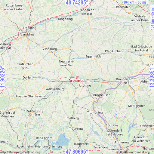
Aresing GPS coordinates[2]
48° 16' 37.344" North, 12° 36' 19.368" East
| Map corner | latitude | longitude |
|---|---|---|
| Upper-left | 48.74285°, | 11.90226° |
| Center: | 48.27704°, | 12.60538° |
| Lower-right: | 47.80695°, | 13.30851° |
| Map W x H: | 104.1×104.1 km | = 64.7×64.7mi |
| max Lat: | 55.01917° ⇑91.5% North |
| Aresing: | 48.27704° |
| min Lat: | ⇓8.5% South 47.40724° |
| min Long | Aresing | max Long |
| 5.92978° | 12.60538° | 14.98853° |
| W 88.9%⇐ | ⇒11.1% E |
Elevation
Elevation of Aresing is 397 m = 1302 ft, and this is 147.9 m = 485 ft above average elevation for this country.
| Max E: |
1256 m = 4121 ft | 25.1% |
| Aresing | 397 m 1302 ft | |
| Avg. | 249.1 m = 817 ft | |
Min E: |
-5 m = -16 ft | 74.9% |
See also: Germany elevation on elevation.city.
Geographical zone
Aresing is located in North temperate zone (between Tropic of Cancer and the Arctic Circle). Distance of this North polar circle is 2033.3 km =1263.4 mi to North.| Distance of | km | miles | from Aresing |
|---|---|---|---|
| North Pole | 4639.2 | 2882.7 | to North |
| Arctic Circle | 2033.3 | 1263.4 | to North |
| Tropic Cancer | 2762 | 1716.2 | to South |
| Equator | 5367.9 | 3335.5 | to South |


Nearby cities:
15 places around Aresing: (largest is in red/bold)
• Altötting
7.8 km =4.8 mi,  137°
137°
• Erharting
1.8 km =1.1 mi,  293°
293°
• Geratskirchen
8 km =5 mi,  31°
31°
• Mühldorf
7.1 km =4.4 mi,  241°
241°
• Neuötting
7.4 km =4.6 mi,  122°
122°
• Niederbergkirchen
9 km =5.6 mi,  299°
299°
• Niedertaufkirchen
7.5 km =4.7 mi,  326°
326°
• Pleiskirchen
3.4 km =2.1 mi,  351°
351°
• Polling
7.3 km =4.5 mi,  203°
203°
• Reischach
9.1 km =5.7 mi,  80°
80°
• Rohrbach
3.9 km =2.4 mi, 290°
• Teising
5.6 km =3.5 mi,  175°
175°
• Töging am Inn
2.4 km =1.5 mi,  219°
219°
• Tüßling
7.2 km =4.5 mi, 183°
• Winhöring
3.5 km =2.2 mi,  109°
109°
Sources, notices
• [Note1] Compared only with cities in Germany existing in our database
• [Src1] Map data: © OpenStreetMap contributors (CC-BY-SA)
• [Src2] Other city data from geonames.org with taken over terms of usage.
• [Src3] Geographical zone / Annual Mean Temperature by Robert A. Rohde @ Wikipedia
