Altersbach geodata
Altersbach (Thuringia) is a seat of a fourth-order administrative division; located in Germany in Europe/Berlin (GMT+2) time zone. With population of 569 people, there are 8979 cities with bigger population in this country. Compared to other cities in Germany, 52% of cities are located further ↓South; 59.4% of cities are located further ←West and 81.9% of cities have lower elevation than Altersbach. Note1
Administrative division(s):
- Level 1: Thuringia
- Level 3: Landkreis Schmalkalden-Meiningen
- Level 4: Steinbach-Hallenberg, Kurort


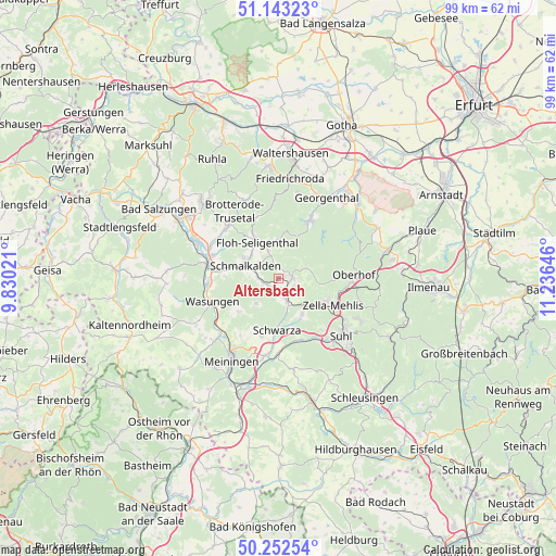
Altersbach GPS coordinates[2]
50° 42' 0" North, 10° 31' 59.988" East
| Map corner | latitude | longitude |
|---|---|---|
| Upper-left | 51.14323°, | 9.83021° |
| Center: | 50.7°, | 10.53333° |
| Lower-right: | 50.25254°, | 11.23646° |
| Map W x H: | 99×99 km | = 61.5×61.5mi |
| max Lat: | 55.01917° ⇑48% North |
| Altersbach: | 50.7° |
| min Lat: | ⇓52% South 47.40724° |
| min Long | Altersbach | max Long |
| 5.92978° | 10.53333° | 14.98853° |
| W 59.4%⇐ | ⇒40.6% E |
Elevation
Elevation of Altersbach is 445 m = 1460 ft, and this is 195.9 m = 643 ft above average elevation for this country.
| Max E: |
1256 m = 4121 ft | 18.1% |
| Altersbach | 445 m 1460 ft | |
| Avg. | 249.1 m = 817 ft | |
Min E: |
-5 m = -16 ft | 81.9% |
See also: Germany elevation on elevation.city.
Geographical zone
Altersbach is located in North temperate zone (between Tropic of Cancer and the Arctic Circle). Distance of this North polar circle is 1763.9 km =1096 mi to North.| Distance of | km | miles | from Altersbach |
|---|---|---|---|
| North Pole | 4369.8 | 2715.3 | to North |
| Arctic Circle | 1763.9 | 1096 | to North |
| Tropic Cancer | 3031.4 | 1883.6 | to South |
| Equator | 5637.3 | 3502.9 | to South |


Nearby cities:
15 places around Altersbach: (largest is in red/bold)
• Benshausen
7.3 km =4.5 mi,  139°
139°
• Bermbach
5.1 km =3.2 mi,  119°
119°
• Breitenbach
3.2 km =2 mi,  247°
247°
• Christes
5.1 km =3.2 mi,  223°
223°
• Kühndorf
10.6 km =6.6 mi,  196°
196°
• Metzels
9.1 km =5.7 mi,  229°
229°
• Oberschönau
6.2 km =3.9 mi,  72°
72°
• Rotterode
2 km =1.2 mi,  46°
46°
• Schmalkalden
6.7 km =4.2 mi,  290°
290°
• Schwarza
9 km =5.6 mi,  181°
181°
• Springstille
1.5 km =0.9 mi,  194°
194°
• Steinbach-Hallenberg
2.3 km =1.4 mi,  100°
100°
• Unterschönau
4 km =2.5 mi,  62°
62°
• Viernau
4.5 km =2.8 mi,  157°
157°
• Zella-Mehlis
10.2 km =6.3 mi, 118°
Sources, notices
• [Note1] Compared only with cities in Germany existing in our database
• [Src1] Map data: © OpenStreetMap contributors (CC-BY-SA)
• [Src2] Other city data from geonames.org with taken over terms of usage.
• [Src3] Geographical zone / Annual Mean Temperature by Robert A. Rohde @ Wikipedia
