Dietenheim geodata
Dietenheim (Baden-Württemberg) is a populated place; located in Germany in Europe/Berlin (GMT+2) time zone. With population of 6,630 people, there are 2274 cities with bigger population in this country. Compared to other cities in Germany, 92.5% of cities are located further ↑North; 51.3% of cities are located further ←West and 89.9% of cities have lower elevation than Dietenheim. Note1
Administrative division(s):
- Level 1: Baden-Württemberg
- Level 2: Tübingen Region
- Level 3: Alb-Donau-Kreis
- Level 4: Dietenheim


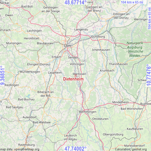
Dietenheim GPS coordinates[2]
48° 12' 38.592" North, 10° 4' 17.868" East
| Map corner | latitude | longitude |
|---|---|---|
| Upper-left | 48.67714°, | 9.36851° |
| Center: | 48.21072°, | 10.07163° |
| Lower-right: | 47.74002°, | 10.77476° |
| Map W x H: | 104.2×104.2 km | = 64.7×64.7mi |
| max Lat: | 55.01917° ⇑92.5% North |
| Dietenheim: | 48.21072° |
| min Lat: | ⇓7.5% South 47.40724° |
| min Long | Dietenheim | max Long |
| 5.92978° | 10.07163° | 14.98853° |
| W 51.3%⇐ | ⇒48.7% E |
Elevation
Elevation of Dietenheim is 513 m = 1683 ft, and this is 263.9 m = 866 ft above average elevation for this country.
| Max E: |
1256 m = 4121 ft | 10.1% |
| Dietenheim | 513 m 1683 ft | |
| Avg. | 249.1 m = 817 ft | |
Min E: |
-5 m = -16 ft | 89.9% |
See also: Germany elevation on elevation.city.
Geographical zone
Dietenheim is located in North temperate zone (between Tropic of Cancer and the Arctic Circle). Distance of this North polar circle is 2040.6 km =1268 mi to North.| Distance of | km | miles | from Dietenheim |
|---|---|---|---|
| North Pole | 4646.5 | 2887.2 | to North |
| Arctic Circle | 2040.6 | 1268 | to North |
| Tropic Cancer | 2754.6 | 1711.6 | to South |
| Equator | 5360.5 | 3330.9 | to South |


Nearby cities:
15 places around Dietenheim: (largest is in red/bold)
• Altenstadt
6.4 km =4 mi,  150°
150°
• Bellenberg
5.4 km =3.4 mi,  15°
15°
• Buch
8.2 km =5.1 mi,  79°
79°
• Burgrieden
10.5 km =6.5 mi,  283°
283°
• Illerrieden
6.8 km =4.2 mi,  347°
347°
• Illertissen
2.7 km =1.7 mi,  59°
59°
• Kellmünz
10.8 km =6.7 mi,  157°
157°
• Kirchberg an der Iller
8.6 km =5.3 mi,  174°
174°
• Oberroth
9.5 km =5.9 mi,  114°
114°
• Osterberg
9.8 km =6.1 mi,  133°
133°
• Schnürpflingen
9 km =5.6 mi,  319°
319°
• Schwendi
8.2 km =5.1 mi,  240°
240°
• Unterroth
7.6 km =4.7 mi,  102°
102°
• Vöhringen
7.6 km =4.7 mi,  6°
6°
• Wain
4.5 km =2.8 mi, 237°
Sources, notices
• [Note1] Compared only with cities in Germany existing in our database
• [Src1] Map data: © OpenStreetMap contributors (CC-BY-SA)
• [Src2] Other city data from geonames.org with taken over terms of usage.
• [Src3] Geographical zone / Annual Mean Temperature by Robert A. Rohde @ Wikipedia
