Waldenbuch geodata
Waldenbuch (Baden-Württemberg) is a populated place; located in Germany in Europe/Berlin (GMT+2) time zone. With population of 8,803 people, there are 1822 cities with bigger population in this country. Compared to other cities in Germany, 87.3% of cities are located further ↑North; 63.5% of cities are located further →East and 68.6% of cities have lower elevation than Waldenbuch. Note1
Administrative division(s):
- Level 1: Baden-Württemberg
- Level 2: Regierungsbezirk Stuttgart
- Level 3: Landkreis Böblingen
- Level 4: Waldenbuch


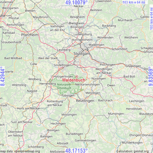
Waldenbuch GPS coordinates[2]
48° 38' 17.88" North, 9° 7' 57.216" East
| Map corner | latitude | longitude |
|---|---|---|
| Upper-left | 49.10079°, | 8.42944° |
| Center: | 48.6383°, | 9.13256° |
| Lower-right: | 48.17153°, | 9.83569° |
| Map W x H: | 103.3×103.3 km | = 64.2×64.2mi |
| max Lat: | 55.01917° ⇑87.3% North |
| Waldenbuch: | 48.6383° |
| min Lat: | ⇓12.7% South 47.40724° |
| min Long | Waldenbuch | max Long |
| 5.92978° | 9.13256° | 14.98853° |
| W 36.5%⇐ | ⇒63.5% E |
Elevation
Elevation of Waldenbuch is 347 m = 1138 ft, and this is 97.9 m = 321 ft above average elevation for this country.
| Max E: |
1256 m = 4121 ft | 31.4% |
| Waldenbuch | 347 m 1138 ft | |
| Avg. | 249.1 m = 817 ft | |
Min E: |
-5 m = -16 ft | 68.6% |
See also: Germany elevation on elevation.city.
Geographical zone
Waldenbuch is located in North temperate zone (between Tropic of Cancer and the Arctic Circle). Distance of this North polar circle is 1993.1 km =1238.5 mi to North.| Distance of | km | miles | from Waldenbuch |
|---|---|---|---|
| North Pole | 4599 | 2857.7 | to North |
| Arctic Circle | 1993.1 | 1238.5 | to North |
| Tropic Cancer | 2802.2 | 1741.2 | to South |
| Equator | 5408.1 | 3360.4 | to South |


Nearby cities:
15 places around Waldenbuch: (largest is in red/bold)
• Altdorf
10 km =6.2 mi,  265°
265°
• Altenriet
8.4 km =5.2 mi,  128°
128°
• Böblingen
10.1 km =6.3 mi,  298°
298°
• Dettenhausen
4.2 km =2.6 mi,  214°
214°
• Filderstadt
6.8 km =4.2 mi,  72°
72°
• Holzgerlingen
8.9 km =5.5 mi, 270°
• Leinfelden-Echterdingen
6.7 km =4.2 mi,  22°
22°
• Neckartailfingen
10.1 km =6.3 mi,  107°
107°
• Neckartenzlingen
9.2 km =5.7 mi, 125°
• Pliezhausen
10.4 km =6.5 mi,  147°
147°
• Schlaitdorf
7.6 km =4.7 mi,  119°
119°
• Schönaich
5.8 km =3.6 mi,  293°
293°
• Sindelfingen
10.9 km =6.8 mi,  308°
308°
• Steinenbronn
3.4 km =2.1 mi,  339°
339°
• Weil im Schönbuch
5.4 km =3.4 mi,  251°
251°
Sources, notices
• [Note1] Compared only with cities in Germany existing in our database
• [Src1] Map data: © OpenStreetMap contributors (CC-BY-SA)
• [Src2] Other city data from geonames.org with taken over terms of usage.
• [Src3] Geographical zone / Annual Mean Temperature by Robert A. Rohde @ Wikipedia
