Steinenbronn geodata
Steinenbronn (Baden-Württemberg) is a seat of a fourth-order administrative division; located in Germany in Europe/Berlin (GMT+2) time zone. With population of 6,089 people, there are 2433 cities with bigger population in this country. Compared to other cities in Germany, 86.9% of cities are located further ↑North; 63.8% of cities are located further →East and 80.9% of cities have lower elevation than Steinenbronn. Note1
Administrative division(s):
- Level 1: Baden-Württemberg
- Level 2: Regierungsbezirk Stuttgart
- Level 3: Landkreis Böblingen
- Level 4: Steinenbronn


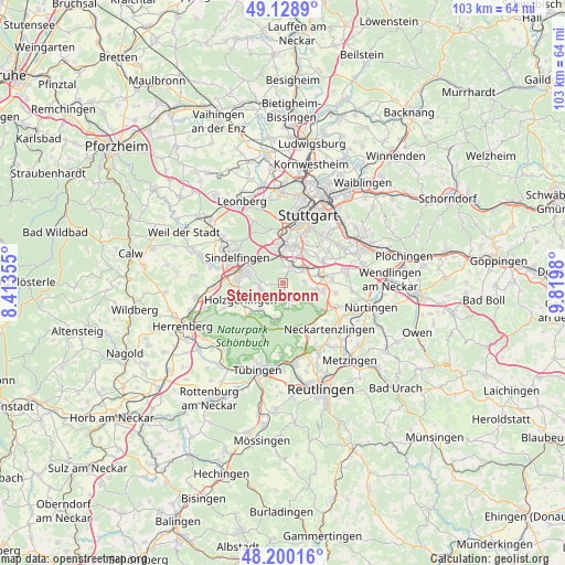
Steinenbronn GPS coordinates[2]
48° 40' 0.012" North, 9° 7' 0.012" East
| Map corner | latitude | longitude |
|---|---|---|
| Upper-left | 49.1289°, | 8.41355° |
| Center: | 48.66667°, | 9.11667° |
| Lower-right: | 48.20016°, | 9.8198° |
| Map W x H: | 103.3×103.3 km | = 64.2×64.2mi |
| max Lat: | 55.01917° ⇑86.9% North |
| Steinenbronn: | 48.66667° |
| min Lat: | ⇓13.1% South 47.40724° |
| min Long | Steinenbronn | max Long |
| 5.92978° | 9.11667° | 14.98853° |
| W 36.2%⇐ | ⇒63.8% E |
Elevation
Elevation of Steinenbronn is 439 m = 1440 ft, and this is 189.9 m = 623 ft above average elevation for this country.
| Max E: |
1256 m = 4121 ft | 19.1% |
| Steinenbronn | 439 m 1440 ft | |
| Avg. | 249.1 m = 817 ft | |
Min E: |
-5 m = -16 ft | 80.9% |
See also: Germany elevation on elevation.city.
Geographical zone
Steinenbronn is located in North temperate zone (between Tropic of Cancer and the Arctic Circle). Distance of this North polar circle is 1989.9 km =1236.5 mi to North.| Distance of | km | miles | from Steinenbronn |
|---|---|---|---|
| North Pole | 4595.8 | 2855.7 | to North |
| Arctic Circle | 1989.9 | 1236.5 | to North |
| Tropic Cancer | 2805.3 | 1743.1 | to South |
| Equator | 5411.2 | 3362.4 | to South |


Nearby cities:
15 places around Steinenbronn: (largest is in red/bold)
• Altdorf
9.7 km =6 mi,  245°
245°
• Altenriet
11.4 km =7.1 mi,  137°
137°
• Böblingen
7.9 km =4.9 mi,  282°
282°
• Dettenhausen
6.7 km =4.2 mi,  190°
190°
• Filderstadt
7.7 km =4.8 mi,  98°
98°
• Hildrizhausen
12 km =7.5 mi, 246°
• Holzgerlingen
8.3 km =5.2 mi, 248°
• Leinfelden-Echterdingen
4.9 km =3 mi,  51°
51°
• Neckartenzlingen
12.2 km =7.6 mi,  134°
134°
• Ostfildern
11.8 km =7.3 mi,  55°
55°
• Schlaitdorf
10.4 km =6.5 mi, 131°
• Schönaich
4.2 km =2.6 mi,  257°
257°
• Sindelfingen
8.2 km =5.1 mi,  296°
296°
• Waldenbuch
3.4 km =2.1 mi,  159°
159°
• Weil im Schönbuch
6.3 km =3.9 mi,  218°
218°
Sources, notices
• [Note1] Compared only with cities in Germany existing in our database
• [Src1] Map data: © OpenStreetMap contributors (CC-BY-SA)
• [Src2] Other city data from geonames.org with taken over terms of usage.
• [Src3] Geographical zone / Annual Mean Temperature by Robert A. Rohde @ Wikipedia
