Kirchsahr geodata
Kirchsahr (Rheinland-Pfalz) is a seat of a fourth-order administrative division; located in Germany in Europe/Berlin (GMT+2) time zone. In our database, there are 11009 cities with bigger population. Compared to other cities in Germany, 52.3% of cities are located further ↑North; 94.6% of cities are located further →East and 58.7% of cities have lower elevation than Kirchsahr. Note1
Administrative division(s):
- Level 1: Rheinland-Pfalz
- Level 3: Landkreis Ahrweiler
- Level 4: Kirchsahr


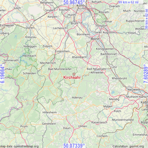
Kirchsahr GPS coordinates[2]
50° 31' 21.144" North, 6° 53' 59.136" East
| Map corner | latitude | longitude |
|---|---|---|
| Upper-left | 50.96745°, | 6.19664° |
| Center: | 50.52254°, | 6.89976° |
| Lower-right: | 50.07339°, | 7.60289° |
| Map W x H: | 99.4×99.4 km | = 61.8×61.8mi |
| max Lat: | 55.01917° ⇑52.3% North |
| Kirchsahr: | 50.52254° |
| min Lat: | ⇓47.7% South 47.40724° |
| min Long | Kirchsahr | max Long |
| 5.92978° | 6.89976° | 14.98853° |
| W 5.4%⇐ | ⇒94.6% E |
Elevation
Elevation of Kirchsahr is 282 m = 925 ft, and this is 32.9 m = 108 ft above average elevation for this country.
| Max E: |
1256 m = 4121 ft | 41.3% |
| Kirchsahr | 282 m 925 ft | |
| Avg. | 249.1 m = 817 ft | |
Min E: |
-5 m = -16 ft | 58.7% |
See also: Germany elevation on elevation.city.
Geographical zone
Kirchsahr is located in North temperate zone (between Tropic of Cancer and the Arctic Circle). Distance of this North polar circle is 1783.6 km =1108.3 mi to North.| Distance of | km | miles | from Kirchsahr |
|---|---|---|---|
| North Pole | 4389.5 | 2727.5 | to North |
| Arctic Circle | 1783.6 | 1108.3 | to North |
| Tropic Cancer | 3011.7 | 1871.4 | to South |
| Equator | 5617.6 | 3490.6 | to South |


Nearby cities:
15 places around Kirchsahr: (largest is in red/bold)
• Ahrbrück
7.7 km =4.8 mi,  125°
125°
• Altenahr
6.6 km =4.1 mi,  95°
95°
• Bad Münstereifel
10.3 km =6.4 mi,  291°
291°
• Berg
5 km =3.1 mi,  43°
43°
• Harscheid
7 km =4.3 mi,  184°
184°
• Hönningen
7.2 km =4.5 mi,  150°
150°
• Hümmel
10.3 km =6.4 mi,  232°
232°
• Insul
10 km =6.2 mi,  173°
173°
• Kalenborn
7.7 km =4.8 mi,  66°
66°
• Kesseling
9.3 km =5.8 mi,  117°
117°
• Lind
3.5 km =2.2 mi,  136°
136°
• Mayschoß
8.3 km =5.2 mi,  91°
91°
• Rech
9.5 km =5.9 mi, 93°
• Schuld
8.4 km =5.2 mi,  185°
185°
• Sierscheid
7.4 km =4.6 mi, 170°
Sources, notices
• [Note1] Compared only with cities in Germany existing in our database
• [Src1] Map data: © OpenStreetMap contributors (CC-BY-SA)
• [Src2] Other city data from geonames.org with taken over terms of usage.
• [Src3] Geographical zone / Annual Mean Temperature by Robert A. Rohde @ Wikipedia
