Butjadingen geodata
Butjadingen (Lower Saxony) is a seat of a fourth-order administrative division; located in Germany in Europe/Berlin (GMT+2) time zone. With population of 6,597 people, there are 2280 cities with bigger population in this country. Compared to other cities in Germany, 86.1% of cities are located further ↓South; 72.6% of cities are located further →East and 99.8% of cities have higher elevation than Butjadingen. Note1
Administrative division(s):
- Level 1: Lower Saxony
- Level 3: Landkreis Wesermarsch
- Level 4: Butjadingen


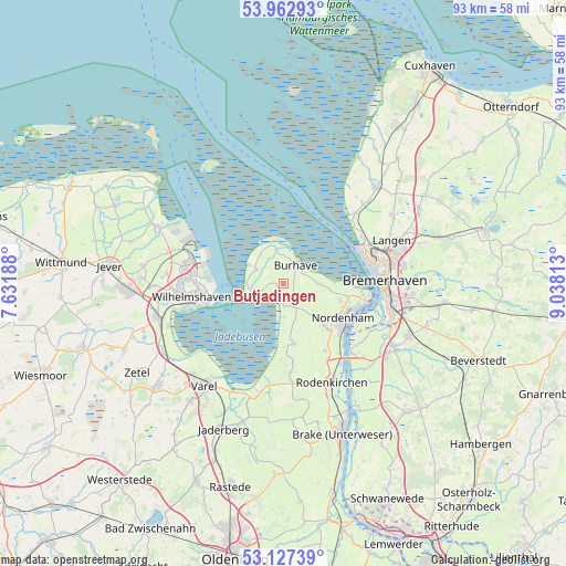
Butjadingen GPS coordinates[2]
53° 32' 49.992" North, 8° 20' 6" East
| Map corner | latitude | longitude |
|---|---|---|
| Upper-left | 53.96293°, | 7.63188° |
| Center: | 53.54722°, | 8.335° |
| Lower-right: | 53.12739°, | 9.03813° |
| Map W x H: | 92.9×92.9 km | = 57.7×57.7mi |
| max Lat: | 55.01917° ⇑13.9% North |
| Butjadingen: | 53.54722° |
| min Lat: | ⇓86.1% South 47.40724° |
| min Long | Butjadingen | max Long |
| 5.92978° | 8.335° | 14.98853° |
| W 27.4%⇐ | ⇒72.6% E |
Elevation
Elevation of Butjadingen is -2 m = -7 ft, and this is 251.1 m = 824 ft below average elevation for this country.
| Max E: |
1256 m = 4121 ft | 99.8% |
| Avg. | 249.1 m = 817 ft | |
| Butjadingen | -2 m = -7 ft | |
Min E: |
-5 m = -16 ft | 0.2% |
See also: Germany elevation on elevation.city.
Geographical zone
Butjadingen is located in North temperate zone (between Tropic of Cancer and the Arctic Circle). Distance of this North polar circle is 1447.3 km =899.3 mi to North.| Distance of | km | miles | from Butjadingen |
|---|---|---|---|
| North Pole | 4053.2 | 2518.5 | to North |
| Arctic Circle | 1447.3 | 899.3 | to North |
| Tropic Cancer | 3348 | 2080.4 | to South |
| Equator | 5953.9 | 3699.6 | to South |


Nearby cities:
15 places around Butjadingen: (largest is in red/bold)
• Bremerhaven
16 km =9.9 mi,  88°
88°
• Dorum
21.9 km =13.6 mi,  44°
44°
• Fedderwarden
19.3 km =12 mi,  274°
274°
• Langen
18.4 km =11.4 mi,  69°
69°
• Loxstedt
22.7 km =14.1 mi,  113°
113°
• Misselwarden
18.6 km =11.6 mi, 40°
• Mulsum
19.4 km =12.1 mi,  46°
46°
• Nordenham
11.8 km =7.3 mi,  125°
125°
• Padingbüttel
21.4 km =13.3 mi, 37°
• Sande
21.7 km =13.5 mi,  257°
257°
• Schiffdorf
20.9 km =13 mi, 94°
• Sillenstede
23.3 km =14.5 mi,  277°
277°
• Varel
21.3 km =13.2 mi,  218°
218°
• Wilhelmshaven
14.8 km =9.2 mi, 262°
• Wremen
16.6 km =10.3 mi, 46°
Sources, notices
• [Note1] Compared only with cities in Germany existing in our database
• [Src1] Map data: © OpenStreetMap contributors (CC-BY-SA)
• [Src2] Other city data from geonames.org with taken over terms of usage.
• [Src3] Geographical zone / Annual Mean Temperature by Robert A. Rohde @ Wikipedia
