Wilhelmshaven geodata
Wilhelmshaven (Lower Saxony) is a seat of a third-order administrative division; located in Germany in Europe/Berlin (GMT+2) time zone. With population of 84,393 people, there are 116 cities with bigger population in this country. Compared to other cities in Germany, 85.9% of cities are located further ↓South; 75.3% of cities are located further →East and 97.6% of cities have higher elevation than Wilhelmshaven. Note1
Administrative division(s):
- Level 1: Lower Saxony
- Level 3: Kreisfreie Stadt Wilhelmshaven
- Level 4: Wilhelmshaven


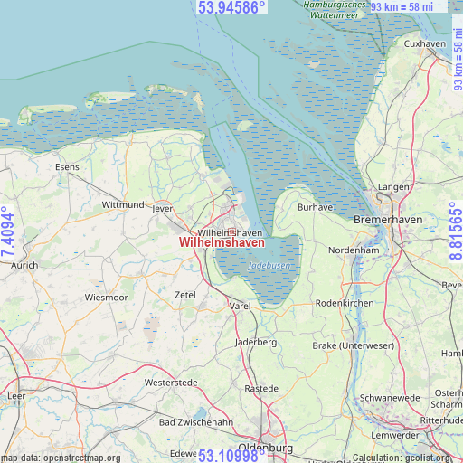
Wilhelmshaven GPS coordinates[2]
53° 31' 47.928" North, 8° 6' 45.108" East
| Map corner | latitude | longitude |
|---|---|---|
| Upper-left | 53.94586°, | 7.4094° |
| Center: | 53.52998°, | 8.11253° |
| Lower-right: | 53.10998°, | 8.81565° |
| Map W x H: | 92.9×92.9 km | = 57.7×57.7mi |
| max Lat: | 55.01917° ⇑14.1% North |
| Wilhelmshaven: | 53.52998° |
| min Lat: | ⇓85.9% South 47.40724° |
| min Long | Wilhelmshaven | max Long |
| 5.92978° | 8.11253° | 14.98853° |
| W 24.7%⇐ | ⇒75.3% E |
Elevation
Elevation of Wilhelmshaven is 3 m = 10 ft, and this is 246.1 m = 807 ft below average elevation for this country.
| Max E: |
1256 m = 4121 ft | 97.6% |
| Avg. | 249.1 m = 817 ft | |
| Wilhelmshaven | 3 m = 10 ft | |
Min E: |
-5 m = -16 ft | 2.4% |
See also: Wilhelmshaven elevation on elevation.city.
Geographical zone
Wilhelmshaven is located in North temperate zone (between Tropic of Cancer and the Arctic Circle). Distance of this North polar circle is 1449.2 km =900.5 mi to North.| Distance of | km | miles | from Wilhelmshaven |
|---|---|---|---|
| North Pole | 4055.1 | 2519.7 | to North |
| Arctic Circle | 1449.2 | 900.5 | to North |
| Tropic Cancer | 3346.1 | 2079.2 | to South |
| Equator | 5952 | 3698.4 | to South |


Nearby cities:
15 places around Wilhelmshaven: (largest is in red/bold)
• Bockhorn
15.8 km =9.8 mi,  203°
203°
• Butjadingen
14.8 km =9.2 mi,  82°
82°
• Carolinensiel
27.2 km =16.9 mi,  311°
311°
• Fedderwarden
5.7 km =3.5 mi, 307°
• Friedeburg
20.5 km =12.7 mi,  244°
244°
• Jever
15 km =9.3 mi,  288°
288°
• Nordenham
24.8 km =15.4 mi,  101°
101°
• Sande
7.1 km =4.4 mi,  246°
246°
• Schillig
20.2 km =12.6 mi,  342°
342°
• Schortens
10.7 km =6.6 mi,  271°
271°
• Sillenstede
9.8 km =6.1 mi,  300°
300°
• Varel
14.9 km =9.3 mi,  173°
173°
• Wiesmoor
28.1 km =17.5 mi, 243°
• Wittmund
22.7 km =14.1 mi,  283°
283°
• Zetel
15.2 km =9.4 mi,  214°
214°
Sources, notices
• [Note1] Compared only with cities in Germany existing in our database
• [Src1] Map data: © OpenStreetMap contributors (CC-BY-SA)
• [Src2] Other city data from geonames.org with taken over terms of usage.
• [Src3] Geographical zone / Annual Mean Temperature by Robert A. Rohde @ Wikipedia
