Sillenstede geodata
Sillenstede (Lower Saxony) is a populated place; located in Germany in Europe/Berlin (GMT+2) time zone. With population of 2,220 people, there are 4782 cities with bigger population in this country. Compared to other cities in Germany, 86.5% of cities are located further ↓South; 77.3% of cities are located further →East and 97% of cities have higher elevation than Sillenstede. Note1


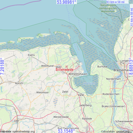
Sillenstede GPS coordinates[2]
53° 34' 27.732" North, 7° 59' 6" East
| Map corner | latitude | longitude |
|---|---|---|
| Upper-left | 53.98981°, | 7.28188° |
| Center: | 53.57437°, | 7.985° |
| Lower-right: | 53.1548°, | 8.68813° |
| Map W x H: | 92.8×92.8 km | = 57.7×57.7mi |
| max Lat: | 55.01917° ⇑13.5% North |
| Sillenstede: | 53.57437° |
| min Lat: | ⇓86.5% South 47.40724° |
| min Long | Sillenstede | max Long |
| 5.92978° | 7.985° | 14.98853° |
| W 22.7%⇐ | ⇒77.3% E |
Elevation
Elevation of Sillenstede is 4 m = 13 ft, and this is 245.1 m = 804 ft below average elevation for this country.
| Max E: |
1256 m = 4121 ft | 97% |
| Avg. | 249.1 m = 817 ft | |
| Sillenstede | 4 m = 13 ft | |
Min E: |
-5 m = -16 ft | 3% |
See also: Germany elevation on elevation.city.
Geographical zone
Sillenstede is located in North temperate zone (between Tropic of Cancer and the Arctic Circle). Distance of this North polar circle is 1444.3 km =897.4 mi to North.| Distance of | km | miles | from Sillenstede |
|---|---|---|---|
| North Pole | 4050.2 | 2516.7 | to North |
| Arctic Circle | 1444.3 | 897.4 | to North |
| Tropic Cancer | 3351 | 2082.2 | to South |
| Equator | 5956.9 | 3701.4 | to South |


Nearby cities:
15 places around Sillenstede: (largest is in red/bold)
• Bockhorn
19.5 km =12.1 mi,  173°
173°
• Carolinensiel
17.7 km =11 mi,  316°
316°
• Dunum
22.3 km =13.9 mi,  277°
277°
• Fedderwarden
4.1 km =2.5 mi,  110°
110°
• Friedeburg
17.1 km =10.6 mi,  215°
215°
• Jever
5.7 km =3.5 mi,  269°
269°
• Sande
8 km =5 mi, 165°
• Schillig
14.6 km =9.1 mi,  9°
9°
• Schortens
5.1 km =3.2 mi,  206°
206°
• Stedesdorf
22 km =13.7 mi,  287°
287°
• Varel
22.1 km =13.7 mi,  153°
153°
• Werdum
19.8 km =12.3 mi,  297°
297°
• Wilhelmshaven
9.8 km =6.1 mi,  120°
120°
• Wittmund
13.6 km =8.5 mi, 271°
• Zetel
17.5 km =10.9 mi,  180°
180°
Sources, notices
• [Note1] Compared only with cities in Germany existing in our database
• [Src1] Map data: © OpenStreetMap contributors (CC-BY-SA)
• [Src2] Other city data from geonames.org with taken over terms of usage.
• [Src3] Geographical zone / Annual Mean Temperature by Robert A. Rohde @ Wikipedia
