Bad Münstereifel geodata
Bad Münstereifel (North Rhine-Westphalia) is a populated place; located in Germany in Europe/Berlin (GMT+2) time zone. With population of 19,051 people, there are 820 cities with bigger population in this country. Compared to other cities in Germany, 51.5% of cities are located further ↑North; 95.9% of cities are located further →East and 58.8% of cities have lower elevation than Bad Münstereifel. Note1
Administrative division(s):
- Level 1: North Rhine-Westphalia
- Level 2: Regierungsbezirk Köln
- Level 3: Kreis Euskirchen
- Level 4: Bad Münstereifel


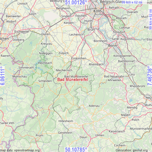
Bad Münstereifel GPS coordinates[2]
50° 33' 24.012" North, 6° 45' 51.264" East
| Map corner | latitude | longitude |
|---|---|---|
| Upper-left | 51.00126°, | 6.06111° |
| Center: | 50.55667°, | 6.76424° |
| Lower-right: | 50.10785°, | 7.46736° |
| Map W x H: | 99.3×99.3 km | = 61.7×61.7mi |
| max Lat: | 55.01917° ⇑51.5% North |
| Bad Münstereifel: | 50.55667° |
| min Lat: | ⇓48.5% South 47.40724° |
| min Long | Bad Münstereif | max Long |
| 5.92978° | 6.76424° | 14.98853° |
| W 4.1%⇐ | ⇒95.9% E |
Elevation
Elevation of Bad Münstereifel is 283 m = 928 ft, and this is 33.9 m = 111 ft above average elevation for this country.
| Max E: |
1256 m = 4121 ft | 41.2% |
| Bad Münstereifel | 283 m 928 ft | |
| Avg. | 249.1 m = 817 ft | |
Min E: |
-5 m = -16 ft | 58.8% |
See also: Germany elevation on elevation.city.
Geographical zone
Bad Münstereifel is located in North temperate zone (between Tropic of Cancer and the Arctic Circle). Distance of this North polar circle is 1779.8 km =1105.9 mi to North.| Distance of | km | miles | from Bad Münstereifel |
|---|---|---|---|
| North Pole | 4385.7 | 2725.1 | to North |
| Arctic Circle | 1779.8 | 1105.9 | to North |
| Tropic Cancer | 3015.5 | 1873.7 | to South |
| Equator | 5621.4 | 3493 | to South |


Nearby cities:
15 places around Bad Münstereifel: (largest is in red/bold)
• Berg
13 km =8.1 mi,  90°
90°
• Eichenbach
14.2 km =8.8 mi,  164°
164°
• Euskirchen
11.7 km =7.3 mi,  7°
7°
• Harscheid
14.1 km =8.8 mi,  140°
140°
• Hümmel
10.1 km =6.3 mi,  172°
172°
• Kall
14.3 km =8.9 mi,  263°
263°
• Kirchsahr
10.3 km =6.4 mi,  111°
111°
• Lind
13.5 km =8.4 mi,  117°
117°
• Mechernich
8.9 km =5.5 mi,  297°
297°
• Nettersheim
11.9 km =7.4 mi,  233°
233°
• Ohlenhard
11.9 km =7.4 mi,  179°
179°
• Rheinbach
15.1 km =9.4 mi,  59°
59°
• Schuld
15 km =9.3 mi, 143°
• Sierscheid
15.5 km =9.6 mi, 135°
• Wershofen
12.9 km =8 mi, 164°
Sources, notices
• [Note1] Compared only with cities in Germany existing in our database
• [Src1] Map data: © OpenStreetMap contributors (CC-BY-SA)
• [Src2] Other city data from geonames.org with taken over terms of usage.
• [Src3] Geographical zone / Annual Mean Temperature by Robert A. Rohde @ Wikipedia
