Hirtshals geodata
Hirtshals (North Denmark) is a populated place; located in Denmark in Europe/Copenhagen (GMT+2) time zone. With population of 6,653 people, there are 109 cities with bigger population in this country. Compared to other cities in Denmark, 99.7% of cities are located further ↓South; 62.9% of cities are located further →East and 59.6% of cities have higher elevation than Hirtshals. Note1


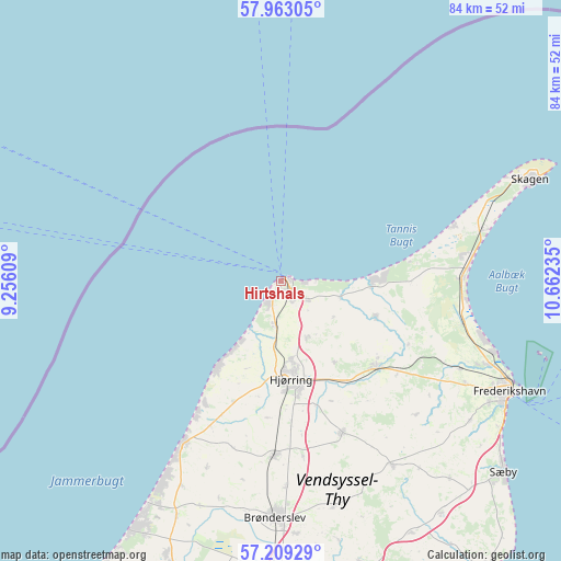
Hirtshals GPS coordinates[2]
57° 35' 17.232" North, 9° 57' 33.192" East
| Map corner | latitude | longitude |
|---|---|---|
| Upper-left | 57.96305°, | 9.25609° |
| Center: | 57.58812°, | 9.95922° |
| Lower-right: | 57.20929°, | 10.66235° |
| Map W x H: | 83.8×83.8 km | = 52.1×52.1mi |
| max Lat: | 57.72093° ⇑0.3% North |
| Hirtshals: | 57.58812° |
| min Lat: | ⇓99.7% South 54.57644° |
| min Long | Hirtshals | max Long |
| 8.12605° | 9.95922° | 15.18662° |
| W 37.1%⇐ | ⇒62.9% E |
Elevation
Elevation of Hirtshals is 16 m = 52 ft, and this is 11.3 m = 37 ft below average elevation for this country.
| Max E: |
114 m = 374 ft | 59.6% |
| Avg. | 27.3 m = 90 ft | |
| Hirtshals | 16 m = 52 ft | |
Min E: |
0 m = 0 ft | 40.4% |
See also: Denmark elevation on elevation.city.
Geographical zone
Hirtshals is located in North temperate zone (between Tropic of Cancer and the Arctic Circle). Distance of this North polar circle is 998 km =620.1 mi to North.| Distance of | km | miles | from Hirtshals |
|---|---|---|---|
| North Pole | 3603.9 | 2239.4 | to North |
| Arctic Circle | 998 | 620.1 | to North |
| Tropic Cancer | 3797.3 | 2359.5 | to South |
| Equator | 6403.2 | 3978.8 | to South |


Nearby cities:
15 places around Hirtshals: (largest is in red/bold)
• Brønderslev
35.4 km =22 mi,  181°
181°
• Frederikshavn
38.2 km =23.7 mi,  115°
115°
• Hjallerup
48.4 km =30.1 mi,  166°
166°
• Hjørring
13.9 km =8.6 mi, 174°
• Kås
46.7 km =29 mi,  201°
201°
• Løkken
28.3 km =17.6 mi,  211°
211°
• Pandrup
44.2 km =27.5 mi, 202°
• Sindal
19.5 km =12.1 mi,  131°
131°
• Skagen
40 km =24.9 mi,  68°
68°
• Strandby
33.8 km =21 mi,  108°
108°
• Sæby
44.1 km =27.4 mi, 130°
• Tårs
24.6 km =15.3 mi,  157°
157°
• Vestbjerg
50.8 km =31.6 mi, 179°
• Vrå
26.1 km =16.2 mi, 182°
• Åbybro
49.3 km =30.6 mi, 196°
Sources, notices
• [Note1] Compared only with cities in Denmark existing in our database
• [Src1] Map data: © OpenStreetMap contributors (CC-BY-SA)
• [Src2] Other city data from geonames.org with taken over terms of usage.
• [Src3] Geographical zone / Annual Mean Temperature by Robert A. Rohde @ Wikipedia
