Sæby geodata
Sæby (North Denmark) is a populated place; located in Denmark in Europe/Copenhagen (GMT+2) time zone. With population of 8,435 people, there are 89 cities with bigger population in this country. Compared to other cities in Denmark, 97.4% of cities are located further ↓South; 57.3% of cities are located further ←West and 83.3% of cities have higher elevation than Sæby. Note1


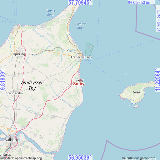
Sæby GPS coordinates[2]
57° 19' 54.768" North, 10° 31' 21.036" East
| Map corner | latitude | longitude |
|---|---|---|
| Upper-left | 57.70945°, | 9.81939° |
| Center: | 57.33188°, | 10.52251° |
| Lower-right: | 56.95039°, | 11.22564° |
| Map W x H: | 84.4×84.4 km | = 52.4×52.4mi |
| max Lat: | 57.72093° ⇑2.6% North |
| Sæby: | 57.33188° |
| min Lat: | ⇓97.4% South 54.57644° |
| min Long | Sæby | max Long |
| 8.12605° | 10.52251° | 15.18662° |
| W 57.3%⇐ | ⇒42.7% E |
Elevation
Elevation of Sæby is 8 m = 26 ft, and this is 19.3 m = 63 ft below average elevation for this country.
| Max E: |
114 m = 374 ft | 83.3% |
| Avg. | 27.3 m = 90 ft | |
| Sæby | 8 m = 26 ft | |
Min E: |
0 m = 0 ft | 16.7% |
See also: Denmark elevation on elevation.city.
Geographical zone
Sæby is located in North temperate zone (between Tropic of Cancer and the Arctic Circle). Distance of this North polar circle is 1026.5 km =637.8 mi to North.| Distance of | km | miles | from Sæby |
|---|---|---|---|
| North Pole | 3632.4 | 2257.1 | to North |
| Arctic Circle | 1026.5 | 637.8 | to North |
| Tropic Cancer | 3768.8 | 2341.8 | to South |
| Equator | 6374.7 | 3961.1 | to South |


Nearby cities:
15 places around Sæby: (largest is in red/bold)
• Brønderslev
35.6 km =22.1 mi,  258°
258°
• Byrum
29.7 km =18.5 mi,  106°
106°
• Dronninglund
23.5 km =14.6 mi,  215°
215°
• Frederikshavn
12.1 km =7.5 mi,  3°
3°
• Hals
39.5 km =24.5 mi,  199°
199°
• Hjallerup
29.3 km =18.2 mi,  230°
230°
• Hjørring
35.5 km =22.1 mi,  294°
294°
• Sindal
24.6 km =15.3 mi,  308°
308°
• Skagen
43.4 km =27 mi, 4°
• Strandby
17.8 km =11.1 mi,  354°
354°
• Tårs
25 km =15.5 mi,  283°
283°
• Vestbjerg
40.5 km =25.2 mi,  236°
236°
• Vester Hassing
37.9 km =23.5 mi, 219°
• Vodskov
39 km =24.2 mi, 230°
• Vrå
34.9 km =21.7 mi,  273°
273°
Sources, notices
• [Note1] Compared only with cities in Denmark existing in our database
• [Src1] Map data: © OpenStreetMap contributors (CC-BY-SA)
• [Src2] Other city data from geonames.org with taken over terms of usage.
• [Src3] Geographical zone / Annual Mean Temperature by Robert A. Rohde @ Wikipedia
