Isenvad geodata
Isenvad (Central Jutland) is a populated place; located in Denmark in Europe/Copenhagen (GMT+2) time zone. With population of 645 people, there are 333 cities with bigger population in this country. Compared to other cities in Denmark, 70.8% of cities are located further ↓South; 85.7% of cities are located further →East and 95.3% of cities have lower elevation than Isenvad. Note1


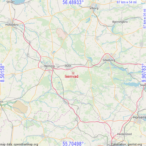
Isenvad GPS coordinates[2]
56° 5' 56.94" North, 9° 12' 16.92" East
| Map corner | latitude | longitude |
|---|---|---|
| Upper-left | 56.48933°, | 8.50158° |
| Center: | 56.09915°, | 9.2047° |
| Lower-right: | 55.70498°, | 9.90783° |
| Map W x H: | 87.2×87.2 km | = 54.2×54.2mi |
| max Lat: | 57.72093° ⇑29.2% North |
| Isenvad: | 56.09915° |
| min Lat: | ⇓70.8% South 54.57644° |
| min Long | Isenvad | max Long |
| 8.12605° | 9.2047° | 15.18662° |
| W 14.3%⇐ | ⇒85.7% E |
Elevation
Elevation of Isenvad is 68 m = 223 ft, and this is 40.7 m = 134 ft above average elevation for this country.
| Max E: |
114 m = 374 ft | 4.7% |
| Isenvad | 68 m 223 ft | |
| Avg. | 27.3 m = 90 ft | |
Min E: |
0 m = 0 ft | 95.3% |
See also: Denmark elevation on elevation.city.
Geographical zone
Isenvad is located in North temperate zone (between Tropic of Cancer and the Arctic Circle). Distance of this North polar circle is 1163.5 km =723 mi to North.| Distance of | km | miles | from Isenvad |
|---|---|---|---|
| North Pole | 3769.4 | 2342.2 | to North |
| Arctic Circle | 1163.5 | 723 | to North |
| Tropic Cancer | 3631.7 | 2256.6 | to South |
| Equator | 6237.6 | 3875.9 | to South |


Nearby cities:
15 places around Isenvad: (largest is in red/bold)
• Bording Kirkeby
8.1 km =5 mi,  17°
17°
• Brande
18 km =11.2 mi,  195°
195°
• Gjellerup
10.7 km =6.6 mi,  299°
299°
• Hammerum
9.7 km =6 mi,  293°
293°
• Herning
14.7 km =9.1 mi, 286°
• Ikast
5.3 km =3.3 mi,  326°
326°
• Karup
23.2 km =14.4 mi,  354°
354°
• Kibæk
22.8 km =14.2 mi,  250°
250°
• Kjellerup
25.2 km =15.7 mi,  34°
34°
• Lind
14 km =8.7 mi,  273°
273°
• Silkeborg
22.5 km =14 mi,  69°
69°
• Snejbjerg
19 km =11.8 mi,  281°
281°
• Sunds
16.9 km =10.5 mi,  315°
315°
• Svejbæk
26.8 km =16.7 mi,  82°
82°
• Virklund
22.1 km =13.7 mi, 80°
Sources, notices
• [Note1] Compared only with cities in Denmark existing in our database
• [Src1] Map data: © OpenStreetMap contributors (CC-BY-SA)
• [Src2] Other city data from geonames.org with taken over terms of usage.
• [Src3] Geographical zone / Annual Mean Temperature by Robert A. Rohde @ Wikipedia
