Skagen geodata
Skagen (North Denmark) is a populated place; located in Denmark in Europe/Copenhagen (GMT+2) time zone. With population of 9,747 people, there are 77 cities with bigger population in this country. Compared to other cities in Denmark, 100% of cities are located further ↓South; 58.2% of cities are located further ←West and 95.6% of cities have higher elevation than Skagen. Note1


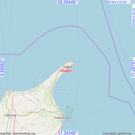
Skagen GPS coordinates[2]
57° 43' 15.348" North, 10° 35' 2.184" East
| Map corner | latitude | longitude |
|---|---|---|
| Upper-left | 58.09449°, | 9.88082° |
| Center: | 57.72093°, | 10.58394° |
| Lower-right: | 57.34348°, | 11.28707° |
| Map W x H: | 83.5×83.5 km | = 51.9×51.9mi |
| max Lat: | 57.72093° ⇑0% North |
| Skagen: | 57.72093° |
| min Lat: | ⇓100% South 54.57644° |
| min Long | Skagen | max Long |
| 8.12605° | 10.58394° | 15.18662° |
| W 58.2%⇐ | ⇒41.8% E |
Elevation
Elevation of Skagen is 3 m = 10 ft, and this is 24.3 m = 80 ft below average elevation for this country.
| Max E: |
114 m = 374 ft | 95.6% |
| Avg. | 27.3 m = 90 ft | |
| Skagen | 3 m = 10 ft | |
Min E: |
0 m = 0 ft | 4.4% |
See also: Denmark elevation on elevation.city.
Geographical zone
Skagen is located in North temperate zone (between Tropic of Cancer and the Arctic Circle). Distance of this North polar circle is 983.2 km =610.9 mi to North.| Distance of | km | miles | from Skagen |
|---|---|---|---|
| North Pole | 3589.1 | 2230.2 | to North |
| Arctic Circle | 983.2 | 610.9 | to North |
| Tropic Cancer | 3812 | 2368.7 | to South |
| Equator | 6418 | 3988 | to South |


Nearby cities:
15 places around Skagen: (largest is in red/bold)
• Brønderslev
63.1 km =39.2 mi,  217°
217°
• Byrum
57.2 km =35.5 mi,  154°
154°
• Dronninglund
64.7 km =40.2 mi,  195°
195°
• Frederikshavn
31.3 km =19.4 mi,  185°
185°
• Hirtshals
40 km =24.9 mi,  248°
248°
• Hjallerup
67.2 km =41.8 mi, 202°
• Hjørring
45.8 km =28.5 mi,  231°
231°
• Løkken
64.9 km =40.3 mi, 233°
• Sindal
35.9 km =22.3 mi, 219°
• Strandby
26 km =16.2 mi, 191°
• Sæby
43.4 km =27 mi,  184°
184°
• Tårs
46.8 km =29.1 mi, 216°
• Vestbjerg
75.4 km =46.9 mi,  209°
209°
• Vodskov
75.9 km =47.2 mi, 206°
• Vrå
56 km =34.8 mi, 223°
Sources, notices
• [Note1] Compared only with cities in Denmark existing in our database
• [Src1] Map data: © OpenStreetMap contributors (CC-BY-SA)
• [Src2] Other city data from geonames.org with taken over terms of usage.
• [Src3] Geographical zone / Annual Mean Temperature by Robert A. Rohde @ Wikipedia
