Ebeltoft geodata
Ebeltoft (Central Jutland) is a populated place; located in Denmark in Europe/Copenhagen (GMT+2) time zone. With population of 7,501 people, there are 96 cities with bigger population in this country. Compared to other cities in Denmark, 76% of cities are located further ↓South; 60.5% of cities are located further ←West and 57.9% of cities have lower elevation than Ebeltoft. Note1


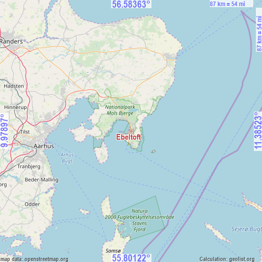
Ebeltoft GPS coordinates[2]
56° 11' 39.912" North, 10° 40' 55.56" East
| Map corner | latitude | longitude |
|---|---|---|
| Upper-left | 56.58363°, | 9.97897° |
| Center: | 56.19442°, | 10.6821° |
| Lower-right: | 55.80122°, | 11.38523° |
| Map W x H: | 87×87 km | = 54.1×54.1mi |
| max Lat: | 57.72093° ⇑24% North |
| Ebeltoft: | 56.19442° |
| min Lat: | ⇓76% South 54.57644° |
| min Long | Ebeltoft | max Long |
| 8.12605° | 10.6821° | 15.18662° |
| W 60.5%⇐ | ⇒39.5% E |
Elevation
Elevation of Ebeltoft is 28 m = 92 ft, and this is 0.7 m = 2 ft above average elevation for this country.
| Max E: |
114 m = 374 ft | 42.1% |
| Ebeltoft | 28 m 92 ft | |
| Avg. | 27.3 m = 90 ft | |
Min E: |
0 m = 0 ft | 57.9% |
See also: Denmark elevation on elevation.city.
Geographical zone
Ebeltoft is located in North temperate zone (between Tropic of Cancer and the Arctic Circle). Distance of this North polar circle is 1152.9 km =716.4 mi to North.| Distance of | km | miles | from Ebeltoft |
|---|---|---|---|
| North Pole | 3758.8 | 2335.6 | to North |
| Arctic Circle | 1152.9 | 716.4 | to North |
| Tropic Cancer | 3642.3 | 2263.2 | to South |
| Equator | 6248.2 | 3882.5 | to South |


Nearby cities:
15 places around Ebeltoft: (largest is in red/bold)
• Auning
32.3 km =20.1 mi,  324°
324°
• Beder
32.7 km =20.3 mi,  242°
242°
• Grenaa
27.4 km =17 mi,  26°
26°
• Hjortshøj
26.4 km =16.4 mi,  283°
283°
• Hornslet
26.1 km =16.2 mi,  301°
301°
• Lystrup
27.9 km =17.3 mi, 279°
• Løgten
24.6 km =15.3 mi,  291°
291°
• Malling
34.9 km =21.7 mi, 239°
• Mårslet
35.3 km =21.9 mi,  246°
246°
• Ryomgård
23.8 km =14.8 mi,  332°
332°
• Rønde
17.5 km =10.9 mi,  312°
312°
• Stavtrup
35.5 km =22.1 mi,  258°
258°
• Tranbjerg
35.6 km =22.1 mi, 251°
• Trige
33.6 km =20.9 mi, 281°
• Århus
29.5 km =18.3 mi, 261°
Sources, notices
• [Note1] Compared only with cities in Denmark existing in our database
• [Src1] Map data: © OpenStreetMap contributors (CC-BY-SA)
• [Src2] Other city data from geonames.org with taken over terms of usage.
• [Src3] Geographical zone / Annual Mean Temperature by Robert A. Rohde @ Wikipedia
