Grenaa geodata
Grenaa (Central Jutland) is a seat of a second-order administrative division; located in Denmark in Europe/Copenhagen (GMT+2) time zone. With population of 14,317 people, there are 53 cities with bigger population in this country. Compared to other cities in Denmark, 82.7% of cities are located further ↓South; 61.4% of cities are located further ←West and 89.8% of cities have higher elevation than Grenaa. Note1


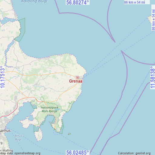
Grenaa GPS coordinates[2]
56° 24' 56.808" North, 10° 52' 41.7" East
| Map corner | latitude | longitude |
|---|---|---|
| Upper-left | 56.80274°, | 10.17513° |
| Center: | 56.41578°, | 10.87825° |
| Lower-right: | 56.02485°, | 11.58138° |
| Map W x H: | 86.5×86.5 km | = 53.7×53.7mi |
| max Lat: | 57.72093° ⇑17.3% North |
| Grenaa: | 56.41578° |
| min Lat: | ⇓82.7% South 54.57644° |
| min Long | Grenaa | max Long |
| 8.12605° | 10.87825° | 15.18662° |
| W 61.4%⇐ | ⇒38.6% E |
Elevation
Elevation of Grenaa is 5 m = 16 ft, and this is 22.3 m = 73 ft below average elevation for this country.
| Max E: |
114 m = 374 ft | 89.8% |
| Avg. | 27.3 m = 90 ft | |
| Grenaa | 5 m = 16 ft | |
Min E: |
0 m = 0 ft | 10.2% |
See also: Denmark elevation on elevation.city.
Geographical zone
Grenaa is located in North temperate zone (between Tropic of Cancer and the Arctic Circle). Distance of this North polar circle is 1128.3 km =701.1 mi to North.| Distance of | km | miles | from Grenaa |
|---|---|---|---|
| North Pole | 3734.2 | 2320.3 | to North |
| Arctic Circle | 1128.3 | 701.1 | to North |
| Tropic Cancer | 3666.9 | 2278.5 | to South |
| Equator | 6272.8 | 3897.7 | to South |


Nearby cities:
15 places around Grenaa: (largest is in red/bold)
• Allingåbro
34.8 km =21.6 mi,  278°
278°
• Assentoft
44.8 km =27.8 mi,  273°
273°
• Auning
30.8 km =19.1 mi, 273°
• Ebeltoft
27.4 km =17 mi,  206°
206°
• Hadsten
52 km =32.3 mi,  259°
259°
• Hjortshøj
42.1 km =26.2 mi,  243°
243°
• Hornslet
36.1 km =22.4 mi,  252°
252°
• Lystrup
44.2 km =27.5 mi, 243°
• Løgten
38.3 km =23.8 mi, 245°
• Randers
52 km =32.3 mi, 275°
• Ryomgård
23.4 km =14.5 mi, 261°
• Rønde
27.9 km =17.3 mi, 242°
• Søften
52.7 km =32.7 mi, 247°
• Trige
48.5 km =30.1 mi, 248°
• Århus
50.3 km =31.3 mi, 235°
Sources, notices
• [Note1] Compared only with cities in Denmark existing in our database
• [Src1] Map data: © OpenStreetMap contributors (CC-BY-SA)
• [Src2] Other city data from geonames.org with taken over terms of usage.
• [Src3] Geographical zone / Annual Mean Temperature by Robert A. Rohde @ Wikipedia
