Aabenraa geodata
Aabenraa (South Denmark) is a seat of a second-order administrative division; located in Denmark in Europe/Copenhagen (GMT+2) time zone. With population of 16,344 people, there are 45 cities with bigger population in this country. Compared to other cities in Denmark, 91.2% of cities are located further ↑North; 81.3% of cities are located further →East and 59.6% of cities have higher elevation than Aabenraa. Note1


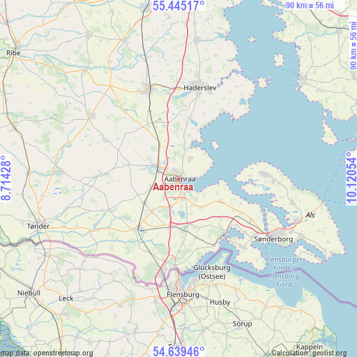
Aabenraa GPS coordinates[2]
55° 2' 39.624" North, 9° 25' 2.676" East
| Map corner | latitude | longitude |
|---|---|---|
| Upper-left | 55.44517°, | 8.71428° |
| Center: | 55.04434°, | 9.41741° |
| Lower-right: | 54.63946°, | 10.12054° |
| Map W x H: | 89.6×89.6 km | = 55.7×55.7mi |
| max Lat: | 57.72093° ⇑91.2% North |
| Aabenraa: | 55.04434° |
| min Lat: | ⇓8.8% South 54.57644° |
| min Long | Aabenraa | max Long |
| 8.12605° | 9.41741° | 15.18662° |
| W 18.7%⇐ | ⇒81.3% E |
Elevation
Elevation of Aabenraa is 16 m = 52 ft, and this is 11.3 m = 37 ft below average elevation for this country.
| Max E: |
114 m = 374 ft | 59.6% |
| Avg. | 27.3 m = 90 ft | |
| Aabenraa | 16 m = 52 ft | |
Min E: |
0 m = 0 ft | 40.4% |
See also: Denmark elevation on elevation.city.
Geographical zone
Aabenraa is located in North temperate zone (between Tropic of Cancer and the Arctic Circle). Distance of this North polar circle is 1280.8 km =795.9 mi to North.| Distance of | km | miles | from Aabenraa |
|---|---|---|---|
| North Pole | 3886.7 | 2415.1 | to North |
| Arctic Circle | 1280.8 | 795.9 | to North |
| Tropic Cancer | 3514.4 | 2183.7 | to South |
| Equator | 6120.4 | 3803 | to South |


Nearby cities:
15 places around Aabenraa: (largest is in red/bold)
• Broager
23.8 km =14.8 mi,  136°
136°
• Dybbøl
25.2 km =15.7 mi,  126°
126°
• Gråsten
18 km =11.2 mi, 140°
• Haderslev
23.2 km =14.4 mi,  11°
11°
• Kruså
21.5 km =13.4 mi,  182°
182°
• Løgumkloster
29.5 km =18.3 mi,  273°
273°
• Løjt Kirkeby
5.7 km =3.5 mi,  28°
28°
• Nordborg
20.6 km =12.8 mi,  85°
85°
• Padborg
24.5 km =15.2 mi,  188°
188°
• Rødekro
6 km =3.7 mi,  299°
299°
• Starup
23.1 km =14.4 mi,  18°
18°
• Sønderborg
28.1 km =17.5 mi,  122°
122°
• Tinglev
15.7 km =9.8 mi,  221°
221°
• Toftlund
27.3 km =17 mi,  305°
305°
• Vojens
23.6 km =14.7 mi,  342°
342°
Sources, notices
• [Note1] Compared only with cities in Denmark existing in our database
• [Src1] Map data: © OpenStreetMap contributors (CC-BY-SA)
• [Src2] Other city data from geonames.org with taken over terms of usage.
• [Src3] Geographical zone / Annual Mean Temperature by Robert A. Rohde @ Wikipedia
