Dybbøl geodata
Dybbøl (South Denmark) is a populated place; located in Denmark in Europe/Copenhagen (GMT+2) time zone. With population of 2,303 people, there are 271 cities with bigger population in this country. Compared to other cities in Denmark, 94.7% of cities are located further ↑North; 71.9% of cities are located further →East and 68.7% of cities have lower elevation than Dybbøl. Note1


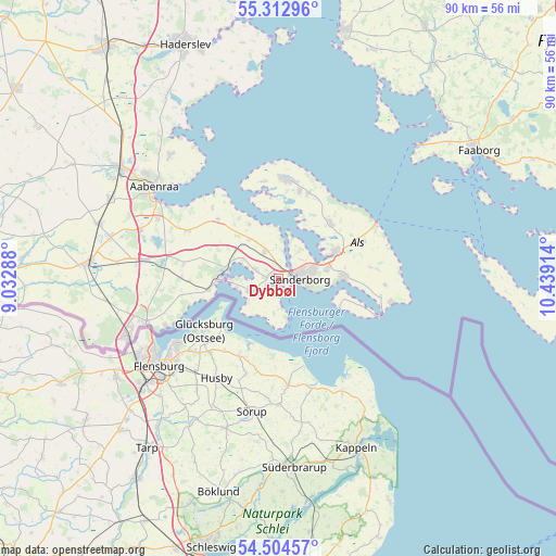
Dybbøl GPS coordinates[2]
54° 54' 38.844" North, 9° 44' 9.636" East
| Map corner | latitude | longitude |
|---|---|---|
| Upper-left | 55.31296°, | 9.03288° |
| Center: | 54.91079°, | 9.73601° |
| Lower-right: | 54.50457°, | 10.43914° |
| Map W x H: | 89.9×89.9 km | = 55.9×55.9mi |
| max Lat: | 57.72093° ⇑94.7% North |
| Dybbøl: | 54.91079° |
| min Lat: | ⇓5.3% South 54.57644° |
| min Long | Dybbøl | max Long |
| 8.12605° | 9.73601° | 15.18662° |
| W 28.1%⇐ | ⇒71.9% E |
Elevation
Elevation of Dybbøl is 36 m = 118 ft, and this is 8.7 m = 29 ft above average elevation for this country.
| Max E: |
114 m = 374 ft | 31.3% |
| Dybbøl | 36 m 118 ft | |
| Avg. | 27.3 m = 90 ft | |
Min E: |
0 m = 0 ft | 68.7% |
See also: Denmark elevation on elevation.city.
Geographical zone
Dybbøl is located in North temperate zone (between Tropic of Cancer and the Arctic Circle). Distance of this North polar circle is 1295.7 km =805.1 mi to North.| Distance of | km | miles | from Dybbøl |
|---|---|---|---|
| North Pole | 3901.6 | 2424.3 | to North |
| Arctic Circle | 1295.7 | 805.1 | to North |
| Tropic Cancer | 3499.6 | 2174.5 | to South |
| Equator | 6105.5 | 3793.8 | to South |


Nearby cities:
15 places around Dybbøl: (largest is in red/bold)
• Aabenraa
25.2 km =15.7 mi,  306°
306°
• Augustenborg
9.8 km =6.1 mi,  62°
62°
• Broager
4.6 km =2.9 mi,  238°
238°
• Faaborg
38.2 km =23.7 mi, 57°
• Gråsten
9 km =5.6 mi,  275°
275°
• Guderup
12.3 km =7.6 mi,  44°
44°
• Høruphav
10.4 km =6.5 mi,  90°
90°
• Kruså
22.4 km =13.9 mi,  252°
252°
• Løjt Kirkeby
26.5 km =16.5 mi,  318°
318°
• Nordborg
16.3 km =10.1 mi,  1°
1°
• Padborg
25.7 km =16 mi, 248°
• Rødekro
31.1 km =19.3 mi,  304°
304°
• Starup
38.9 km =24.2 mi,  340°
340°
• Sønderborg
3.4 km =2.1 mi, 93°
• Tinglev
30.9 km =19.2 mi, 275°
Sources, notices
• [Note1] Compared only with cities in Denmark existing in our database
• [Src1] Map data: © OpenStreetMap contributors (CC-BY-SA)
• [Src2] Other city data from geonames.org with taken over terms of usage.
• [Src3] Geographical zone / Annual Mean Temperature by Robert A. Rohde @ Wikipedia
