Broager geodata
Broager (South Denmark) is a populated place; located in Denmark in Europe/Copenhagen (GMT+2) time zone. With population of 3,376 people, there are 187 cities with bigger population in this country. Compared to other cities in Denmark, 95.9% of cities are located further ↑North; 74% of cities are located further →East and 60.8% of cities have lower elevation than Broager. Note1


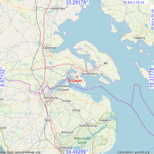
Broager GPS coordinates[2]
54° 53' 21.84" North, 9° 40' 28.74" East
| Map corner | latitude | longitude |
|---|---|---|
| Upper-left | 55.29178°, | 8.97152° |
| Center: | 54.8894°, | 9.67465° |
| Lower-right: | 54.48296°, | 10.37778° |
| Map W x H: | 89.9×89.9 km | = 55.9×55.9mi |
| max Lat: | 57.72093° ⇑95.9% North |
| Broager: | 54.8894° |
| min Lat: | ⇓4.1% South 54.57644° |
| min Long | Broager | max Long |
| 8.12605° | 9.67465° | 15.18662° |
| W 26%⇐ | ⇒74% E |
Elevation
Elevation of Broager is 30 m = 98 ft, and this is 2.7 m = 9 ft above average elevation for this country.
| Max E: |
114 m = 374 ft | 39.2% |
| Broager | 30 m 98 ft | |
| Avg. | 27.3 m = 90 ft | |
Min E: |
0 m = 0 ft | 60.8% |
See also: Denmark elevation on elevation.city.
Geographical zone
Broager is located in North temperate zone (between Tropic of Cancer and the Arctic Circle). Distance of this North polar circle is 1298 km =806.5 mi to North.| Distance of | km | miles | from Broager |
|---|---|---|---|
| North Pole | 3903.9 | 2425.8 | to North |
| Arctic Circle | 1298 | 806.5 | to North |
| Tropic Cancer | 3497.2 | 2173.1 | to South |
| Equator | 6103.1 | 3792.3 | to South |


Nearby cities:
15 places around Broager: (largest is in red/bold)
• Aabenraa
23.8 km =14.8 mi,  316°
316°
• Augustenborg
14.4 km =8.9 mi,  61°
61°
• Dybbøl
4.6 km =2.9 mi, 58°
• Gråsten
6.1 km =3.8 mi,  303°
303°
• Guderup
16.8 km =10.4 mi,  48°
48°
• Haderslev
41.8 km =26 mi,  343°
343°
• Høruphav
14.5 km =9 mi,  80°
80°
• Kruså
18 km =11.2 mi,  256°
256°
• Løjt Kirkeby
26.1 km =16.2 mi,  328°
328°
• Nordborg
19.1 km =11.9 mi,  12°
12°
• Padborg
21.2 km =13.2 mi,  250°
250°
• Rødekro
29.6 km =18.4 mi,  312°
312°
• Starup
40.1 km =24.9 mi,  347°
347°
• Sønderborg
7.6 km =4.7 mi,  73°
73°
• Tinglev
27.3 km =17 mi,  281°
281°
Sources, notices
• [Note1] Compared only with cities in Denmark existing in our database
• [Src1] Map data: © OpenStreetMap contributors (CC-BY-SA)
• [Src2] Other city data from geonames.org with taken over terms of usage.
• [Src3] Geographical zone / Annual Mean Temperature by Robert A. Rohde @ Wikipedia
