Starup geodata
Starup (South Denmark) is a populated place; located in Denmark in Europe/Copenhagen (GMT+2) time zone. With population of 2,091 people, there are 297 cities with bigger population in this country. Compared to other cities in Denmark, 85.4% of cities are located further ↑North; 78.1% of cities are located further →East and 50.9% of cities have higher elevation than Starup. Note1


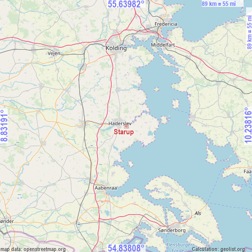
Starup GPS coordinates[2]
55° 14' 27.492" North, 9° 32' 6.108" East
| Map corner | latitude | longitude |
|---|---|---|
| Upper-left | 55.63982°, | 8.83191° |
| Center: | 55.24097°, | 9.53503° |
| Lower-right: | 54.83808°, | 10.23816° |
| Map W x H: | 89.1×89.1 km | = 55.4×55.4mi |
| max Lat: | 57.72093° ⇑85.4% North |
| Starup: | 55.24097° |
| min Lat: | ⇓14.6% South 54.57644° |
| min Long | Starup | max Long |
| 8.12605° | 9.53503° | 15.18662° |
| W 21.9%⇐ | ⇒78.1% E |
Elevation
Elevation of Starup is 21 m = 69 ft, and this is 6.3 m = 21 ft below average elevation for this country.
| Max E: |
114 m = 374 ft | 50.9% |
| Avg. | 27.3 m = 90 ft | |
| Starup | 21 m = 69 ft | |
Min E: |
0 m = 0 ft | 49.1% |
See also: Denmark elevation on elevation.city.
Geographical zone
Starup is located in North temperate zone (between Tropic of Cancer and the Arctic Circle). Distance of this North polar circle is 1259 km =782.3 mi to North.| Distance of | km | miles | from Starup |
|---|---|---|---|
| North Pole | 3864.8 | 2401.5 | to North |
| Arctic Circle | 1259 | 782.3 | to North |
| Tropic Cancer | 3536.3 | 2197.4 | to South |
| Equator | 6142.2 | 3816.6 | to South |


Nearby cities:
15 places around Starup: (largest is in red/bold)
• Aabenraa
23.1 km =14.4 mi,  198°
198°
• Assens
23.4 km =14.5 mi,  82°
82°
• Christiansfeld
13.4 km =8.3 mi,  346°
346°
• Gram
31.3 km =19.4 mi,  279°
279°
• Haderslev
3.1 km =1.9 mi,  287°
287°
• Kolding
28 km =17.4 mi, 351°
• Lunderskov
30.8 km =19.1 mi,  331°
331°
• Løjt Kirkeby
17.5 km =10.9 mi, 195°
• Middelfart
31.9 km =19.8 mi,  22°
22°
• Nordborg
24.2 km =15 mi,  147°
147°
• Rødekro
22.8 km =14.2 mi,  213°
213°
• Sønder Bjert
23.6 km =14.7 mi,  4°
4°
• Toftlund
30.1 km =18.7 mi,  258°
258°
• Vamdrup
26.1 km =16.2 mi,  322°
322°
• Vojens
14.5 km =9 mi,  272°
272°
Sources, notices
• [Note1] Compared only with cities in Denmark existing in our database
• [Src1] Map data: © OpenStreetMap contributors (CC-BY-SA)
• [Src2] Other city data from geonames.org with taken over terms of usage.
• [Src3] Geographical zone / Annual Mean Temperature by Robert A. Rohde @ Wikipedia
