Løjt Kirkeby geodata
Løjt Kirkeby (South Denmark) is a populated place; located in Denmark in Europe/Copenhagen (GMT+2) time zone. With population of 1,975 people, there are 311 cities with bigger population in this country. Compared to other cities in Denmark, 88.3% of cities are located further ↑North; 80.4% of cities are located further →East and 91.2% of cities have lower elevation than Løjt Kirkeby. Note1


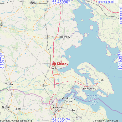
Løjt Kirkeby GPS coordinates[2]
55° 5' 22.524" North, 9° 27' 39.024" East
| Map corner | latitude | longitude |
|---|---|---|
| Upper-left | 55.48996°, | 8.75771° |
| Center: | 55.08959°, | 9.46084° |
| Lower-right: | 54.68517°, | 10.16397° |
| Map W x H: | 89.5×89.5 km | = 55.6×55.6mi |
| max Lat: | 57.72093° ⇑88.3% North |
| Løjt Kirkeby: | 55.08959° |
| min Lat: | ⇓11.7% South 54.57644° |
| min Long | Løjt Kirkeby | max Long |
| 8.12605° | 9.46084° | 15.18662° |
| W 19.6%⇐ | ⇒80.4% E |
Elevation
Elevation of Løjt Kirkeby is 60 m = 197 ft, and this is 32.7 m = 107 ft above average elevation for this country.
| Max E: |
114 m = 374 ft | 8.8% |
| Løjt Kirkeby | 60 m 197 ft | |
| Avg. | 27.3 m = 90 ft | |
Min E: |
0 m = 0 ft | 91.2% |
See also: Denmark elevation on elevation.city.
Geographical zone
Løjt Kirkeby is located in North temperate zone (between Tropic of Cancer and the Arctic Circle). Distance of this North polar circle is 1275.8 km =792.7 mi to North.| Distance of | km | miles | from Løjt Kirkeby |
|---|---|---|---|
| North Pole | 3881.7 | 2412 | to North |
| Arctic Circle | 1275.8 | 792.7 | to North |
| Tropic Cancer | 3519.5 | 2186.9 | to South |
| Equator | 6125.4 | 3806.1 | to South |


Nearby cities:
15 places around Løjt Kirkeby: (largest is in red/bold)
• Aabenraa
5.7 km =3.5 mi,  208°
208°
• Broager
26.1 km =16.2 mi,  148°
148°
• Christiansfeld
29.9 km =18.6 mi,  3°
3°
• Dybbøl
26.5 km =16.5 mi,  138°
138°
• Gråsten
20.8 km =12.9 mi,  155°
155°
• Guderup
28.4 km =17.6 mi,  112°
112°
• Haderslev
17.9 km =11.1 mi,  5°
5°
• Kruså
26.8 km =16.7 mi,  188°
188°
• Nordborg
18.2 km =11.3 mi,  101°
101°
• Rødekro
8.3 km =5.2 mi,  255°
255°
• Starup
17.5 km =10.9 mi,  15°
15°
• Sønderborg
29 km =18 mi,  133°
133°
• Tinglev
21.4 km =13.3 mi,  217°
217°
• Toftlund
27.2 km =16.9 mi,  293°
293°
• Vojens
20 km =12.4 mi,  330°
330°
Sources, notices
• [Note1] Compared only with cities in Denmark existing in our database
• [Src1] Map data: © OpenStreetMap contributors (CC-BY-SA)
• [Src2] Other city data from geonames.org with taken over terms of usage.
• [Src3] Geographical zone / Annual Mean Temperature by Robert A. Rohde @ Wikipedia
