Vojens geodata
Vojens (South Denmark) is a populated place; located in Denmark in Europe/Copenhagen (GMT+2) time zone. With population of 8,019 people, there are 92 cities with bigger population in this country. Compared to other cities in Denmark, 85.1% of cities are located further ↑North; 83.3% of cities are located further →East and 76% of cities have lower elevation than Vojens. Note1


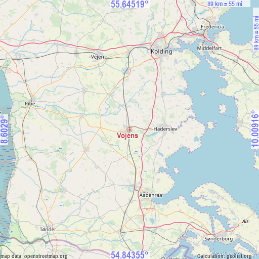
Vojens GPS coordinates[2]
55° 14' 47.004" North, 9° 18' 21.708" East
| Map corner | latitude | longitude |
|---|---|---|
| Upper-left | 55.64519°, | 8.6029° |
| Center: | 55.24639°, | 9.30603° |
| Lower-right: | 54.84355°, | 10.00916° |
| Map W x H: | 89.1×89.1 km | = 55.4×55.4mi |
| max Lat: | 57.72093° ⇑85.1% North |
| Vojens: | 55.24639° |
| min Lat: | ⇓14.9% South 54.57644° |
| min Long | Vojens | max Long |
| 8.12605° | 9.30603° | 15.18662° |
| W 16.7%⇐ | ⇒83.3% E |
Elevation
Elevation of Vojens is 42 m = 138 ft, and this is 14.7 m = 48 ft above average elevation for this country.
| Max E: |
114 m = 374 ft | 24% |
| Vojens | 42 m 138 ft | |
| Avg. | 27.3 m = 90 ft | |
Min E: |
0 m = 0 ft | 76% |
See also: Denmark elevation on elevation.city.
Geographical zone
Vojens is located in North temperate zone (between Tropic of Cancer and the Arctic Circle). Distance of this North polar circle is 1258.4 km =781.9 mi to North.| Distance of | km | miles | from Vojens |
|---|---|---|---|
| North Pole | 3864.2 | 2401.1 | to North |
| Arctic Circle | 1258.4 | 781.9 | to North |
| Tropic Cancer | 3536.9 | 2197.7 | to South |
| Equator | 6142.8 | 3817 | to South |


Nearby cities:
15 places around Vojens: (largest is in red/bold)
• Aabenraa
23.6 km =14.7 mi,  162°
162°
• Christiansfeld
16.9 km =10.5 mi,  42°
42°
• Gram
17 km =10.6 mi,  286°
286°
• Haderslev
11.5 km =7.1 mi,  88°
88°
• Kolding
29.1 km =18.1 mi,  21°
21°
• Lunderskov
26.4 km =16.4 mi,  359°
359°
• Løgumkloster
30.5 km =19 mi,  227°
227°
• Løjt Kirkeby
20 km =12.4 mi,  150°
150°
• Rødding
20.3 km =12.6 mi,  310°
310°
• Rødekro
19.6 km =12.2 mi,  174°
174°
• Starup
14.5 km =9 mi, 92°
• Sønder Bjert
28.3 km =17.6 mi, 35°
• Toftlund
16.3 km =10.1 mi,  246°
246°
• Vamdrup
20.2 km =12.6 mi, 356°
• Vejen
28.2 km =17.5 mi,  337°
337°
Sources, notices
• [Note1] Compared only with cities in Denmark existing in our database
• [Src1] Map data: © OpenStreetMap contributors (CC-BY-SA)
• [Src2] Other city data from geonames.org with taken over terms of usage.
• [Src3] Geographical zone / Annual Mean Temperature by Robert A. Rohde @ Wikipedia
