Los Botados geodata
Los Botados (Monte Plata) is a populated place; located in Dominican Republic in America/Santo_Domingo (GMT-4) time zone. With population of 4,054 people, there are 130 cities with bigger population in this country. Compared to other cities in Dominican Republic, 58.3% of cities are located further ↑North; 76.3% of cities are located further ←West and 53.6% of cities have higher elevation than Los Botados. Note1
Administrative division(s):
- Level 1: Monte Plata
- Level 2: Yamasá
- Level 3: Los Botados (D. M.).
- Level 4: Los Botados (Zona Urbana)


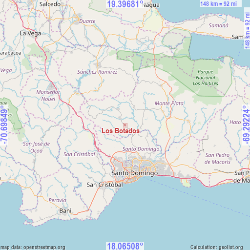
Los Botados GPS coordinates[2]
18° 43' 56.136" North, 69° 59' 43.296" West
| Map corner | latitude | longitude |
|---|---|---|
| Upper-left | 19.39681°, | -70.69849° |
| Center: | 18.73226°, | -69.99536° |
| Lower-right: | 18.06508°, | -69.29224° |
| Map W x H: | 148.1×148.1 km | = 92×92mi |
| max Lat: | 19.89131° ⇑58.3% North |
| Los Botados: | 18.73226° |
| min Lat: | ⇓41.7% South 17.80136° |
| min Long | Los Botados | max Long |
| -71.85022° | -69.99536° | -68.40431° |
| W 76.3%⇐ | ⇒23.7% E |
Elevation
Elevation of Los Botados is 59 m = 194 ft, and this is 107.3 m = 352 ft below average elevation for this country.
| Max E: |
1242 m = 4075 ft | 53.6% |
| Avg. | 166.3 m = 546 ft | |
| Los Botados | 59 m = 194 ft | |
Min E: |
5 m = 16 ft | 46.4% |
See also: Dominican Republic elevation on elevation.city.
Geographical zone
Los Botados is located in North Torrid zone (between Equator and Tropic of Cancer). Distance of this Northern Tropic circle is 523.1 km =325 mi to North.| Distance of | km | miles | from Los Botados |
|---|---|---|---|
| North Pole | 7924.2 | 4923.9 | to North |
| Arctic Circle | 5318.3 | 3304.6 | to North |
| Tropic Cancer | 523.1 | 325 | to North |
| Equator | 2082.8 | 1294.2 | to South |


Nearby cities:
15 places around Los Botados: (largest is in red/bold)
• Cevicos
30.3 km =18.8 mi,  3°
3°
• Cristo Rey
26.6 km =16.5 mi,  165°
165°
• Don Juan
11.8 km =7.3 mi,  25°
25°
• Ensanche Luperón
27.7 km =17.2 mi,  158°
158°
• Esperalvillo
10.1 km =6.3 mi,  335°
335°
• La Agustina
26.6 km =16.5 mi, 165°
• La Julia
30.2 km =18.8 mi, 167°
• Monte Plata
23.8 km =14.8 mi,  69°
69°
• San Carlos
29.4 km =18.3 mi, 160°
• Santo Domingo Este
30.8 km =19.1 mi,  151°
151°
• Santo Domingo Oeste
25.8 km =16 mi,  181°
181°
• Villa Altagracia
19.6 km =12.2 mi,  250°
250°
• Villa Consuelo
29.4 km =18.3 mi, 160°
• Villa Francisca
29.9 km =18.6 mi, 158°
• Yamasá
5.6 km =3.5 mi,  324°
324°
Sources, notices
• [Note1] Compared only with cities in Dominican Republic existing in our database
• [Src1] Map data: © OpenStreetMap contributors (CC-BY-SA)
• [Src2] Other city data from geonames.org with taken over terms of usage.
• [Src3] Geographical zone / Annual Mean Temperature by Robert A. Rohde @ Wikipedia
