Yamasá geodata
Yamasá (Monte Plata) is a populated place; located in Dominican Republic in America/Santo_Domingo (GMT-4) time zone. With population of 11,595 people, there are 58 cities with bigger population in this country. Compared to other cities in Dominican Republic, 55.5% of cities are located further ↑North; 74.9% of cities are located further ←West and 57.3% of cities have lower elevation than Yamasá. Note1
Administrative division(s):
- Level 1: Monte Plata
- Level 2: Yamasá
- Level 3: Yamasá
- Level 4: Yamasá (Zona Urbana)


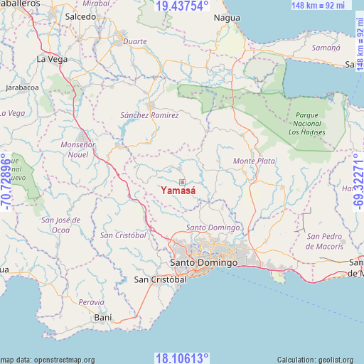
Yamasá GPS coordinates[2]
18° 46' 23.34" North, 70° 1' 32.988" West
| Map corner | latitude | longitude |
|---|---|---|
| Upper-left | 19.43754°, | -70.72896° |
| Center: | 18.77315°, | -70.02583° |
| Lower-right: | 18.10613°, | -69.32271° |
| Map W x H: | 148×148 km | = 92×92mi |
| max Lat: | 19.89131° ⇑55.5% North |
| Yamasá: | 18.77315° |
| min Lat: | ⇓44.5% South 17.80136° |
| min Long | Yamasá | max Long |
| -71.85022° | -70.02583° | -68.40431° |
| W 74.9%⇐ | ⇒25.1% E |
Elevation
Elevation of Yamasá is 89 m = 292 ft, and this is 77.3 m = 254 ft below average elevation for this country.
| Max E: |
1242 m = 4075 ft | 42.7% |
| Avg. | 166.3 m = 546 ft | |
| Yamasá | 89 m = 292 ft | |
Min E: |
5 m = 16 ft | 57.3% |
See also: Dominican Republic elevation on elevation.city.
Geographical zone
Yamasá is located in North Torrid zone (between Equator and Tropic of Cancer). Distance of this Northern Tropic circle is 518.5 km =322.2 mi to North.| Distance of | km | miles | from Yamasá |
|---|---|---|---|
| North Pole | 7919.7 | 4921.1 | to North |
| Arctic Circle | 5313.8 | 3301.8 | to North |
| Tropic Cancer | 518.5 | 322.2 | to North |
| Equator | 2087.4 | 1297 | to South |


Nearby cities:
15 places around Yamasá: (largest is in red/bold)
• Cevicos
26.2 km =16.3 mi,  10°
10°
• Cotuí
33.7 km =20.9 mi,  337°
337°
• Cristo Rey
31.9 km =19.8 mi,  162°
162°
• Don Juan
10.3 km =6.4 mi,  54°
54°
• Ensanche Luperón
33.1 km =20.6 mi, 156°
• Esperalvillo
4.8 km =3 mi,  347°
347°
• Juan Adrián
32.8 km =20.4 mi,  268°
268°
• La Agustina
31.9 km =19.8 mi, 162°
• Los Botados
5.6 km =3.5 mi,  144°
144°
• Monte Plata
25.7 km =16 mi,  81°
81°
• Piedra Blanca
31.6 km =19.6 mi,  284°
284°
• Sabana Grande de Boyá
31 km =19.3 mi, 52°
• Santo Domingo Oeste
30.5 km =19 mi,  174°
174°
• Villa Altagracia
18.9 km =11.7 mi,  233°
233°
• Villa Consuelo
34.8 km =21.6 mi, 157°
Sources, notices
• [Note1] Compared only with cities in Dominican Republic existing in our database
• [Src1] Map data: © OpenStreetMap contributors (CC-BY-SA)
• [Src2] Other city data from geonames.org with taken over terms of usage.
• [Src3] Geographical zone / Annual Mean Temperature by Robert A. Rohde @ Wikipedia
