Cevicos geodata
Cevicos (Sánchez Ramírez) is a populated place; located in Dominican Republic in America/Santo_Domingo (GMT-4) time zone. With population of 4,064 people, there are 129 cities with bigger population in this country. Compared to other cities in Dominican Republic, 55% of cities are located further ↓South; 76.8% of cities are located further ←West and 57.8% of cities have lower elevation than Cevicos. Note1
Administrative division(s):
- Level 1: Sánchez Ramírez
- Level 2: Cevicos
- Level 3: Cevicos
- Level 4: Cevicos (Zona Urbana)


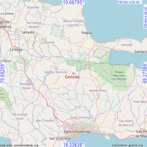
Cevicos GPS coordinates[2]
19° 0' 16.164" North, 69° 58' 44.256" West
| Map corner | latitude | longitude |
|---|---|---|
| Upper-left | 19.66795°, | -70.68209° |
| Center: | 19.00449°, | -69.97896° |
| Lower-right: | 18.33838°, | -69.27584° |
| Map W x H: | 147.8×147.8 km | = 91.8×91.8mi |
| max Lat: | 19.89131° ⇑45% North |
| Cevicos: | 19.00449° |
| min Lat: | ⇓55% South 17.80136° |
| min Long | Cevicos | max Long |
| -71.85022° | -69.97896° | -68.40431° |
| W 76.8%⇐ | ⇒23.2% E |
Elevation
Elevation of Cevicos is 95 m = 312 ft, and this is 71.3 m = 234 ft below average elevation for this country.
| Max E: |
1242 m = 4075 ft | 42.2% |
| Avg. | 166.3 m = 546 ft | |
| Cevicos | 95 m = 312 ft | |
Min E: |
5 m = 16 ft | 57.8% |
See also: Dominican Republic elevation on elevation.city.
Geographical zone
Cevicos is located in North Torrid zone (between Equator and Tropic of Cancer). Distance of this Northern Tropic circle is 492.8 km =306.2 mi to North.| Distance of | km | miles | from Cevicos |
|---|---|---|---|
| North Pole | 7894 | 4905.1 | to North |
| Arctic Circle | 5288.1 | 3285.9 | to North |
| Tropic Cancer | 492.8 | 306.2 | to North |
| Equator | 2113.1 | 1313 | to South |


Nearby cities:
15 places around Cevicos: (largest is in red/bold)
• Agua Santa del Yuna
24.8 km =15.4 mi,  49°
49°
• Arenoso
23.9 km =14.9 mi,  31°
31°
• Castillo
23.2 km =14.4 mi,  347°
347°
• Cotuí
18.7 km =11.6 mi,  286°
286°
• Don Juan
20 km =12.4 mi,  170°
170°
• Esperalvillo
21.9 km =13.6 mi,  195°
195°
• Gonzalo
24.7 km =15.3 mi,  103°
103°
• Hostos
20 km =12.4 mi, 347°
• Los Botados
30.3 km =18.8 mi,  183°
183°
• Majagual
15.6 km =9.7 mi,  74°
74°
• Monte Plata
30 km =18.6 mi,  136°
136°
• Pimentel
24.2 km =15 mi,  325°
325°
• Sabana Grande de Boyá
20.6 km =12.8 mi,  108°
108°
• Villa Riva
20.8 km =12.9 mi,  19°
19°
• Yamasá
26.2 km =16.3 mi,  190°
190°
Sources, notices
• [Note1] Compared only with cities in Dominican Republic existing in our database
• [Src1] Map data: © OpenStreetMap contributors (CC-BY-SA)
• [Src2] Other city data from geonames.org with taken over terms of usage.
• [Src3] Geographical zone / Annual Mean Temperature by Robert A. Rohde @ Wikipedia
