Don Juan geodata
Don Juan (Monte Plata) is a populated place; located in Dominican Republic in America/Santo_Domingo (GMT-4) time zone. With population of 2,396 people, there are 160 cities with bigger population in this country. Compared to other cities in Dominican Republic, 52.1% of cities are located further ↑North; 77.3% of cities are located further ←West and 53.6% of cities have higher elevation than Don Juan. Note1
Administrative division(s):
- Level 1: Monte Plata
- Level 2: Monte Plata
- Level 3: Don Juan (D. M.).
- Level 4: Don Juan (Zona Urbana)


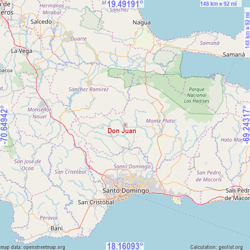
Don Juan GPS coordinates[2]
18° 49' 39.864" North, 69° 56' 46.644" West
| Map corner | latitude | longitude |
|---|---|---|
| Upper-left | 19.49191°, | -70.64942° |
| Center: | 18.82774°, | -69.94629° |
| Lower-right: | 18.16093°, | -69.24317° |
| Map W x H: | 148×148 km | = 92×92mi |
| max Lat: | 19.89131° ⇑52.1% North |
| Don Juan: | 18.82774° |
| min Lat: | ⇓47.9% South 17.80136° |
| min Long | Don Juan | max Long |
| -71.85022° | -69.94629° | -68.40431° |
| W 77.3%⇐ | ⇒22.7% E |
Elevation
Elevation of Don Juan is 59 m = 194 ft, and this is 107.3 m = 352 ft below average elevation for this country.
| Max E: |
1242 m = 4075 ft | 53.6% |
| Avg. | 166.3 m = 546 ft | |
| Don Juan | 59 m = 194 ft | |
Min E: |
5 m = 16 ft | 46.4% |
See also: Dominican Republic elevation on elevation.city.
Geographical zone
Don Juan is located in North Torrid zone (between Equator and Tropic of Cancer). Distance of this Northern Tropic circle is 512.5 km =318.5 mi to North.| Distance of | km | miles | from Don Juan |
|---|---|---|---|
| North Pole | 7913.6 | 4917.3 | to North |
| Arctic Circle | 5307.7 | 3298.1 | to North |
| Tropic Cancer | 512.5 | 318.5 | to North |
| Equator | 2093.4 | 1300.8 | to South |


Nearby cities:
15 places around Don Juan: (largest is in red/bold)
• Bayaguana
33.9 km =21.1 mi,  104°
104°
• Cevicos
20 km =12.4 mi,  350°
350°
• Cotuí
32.9 km =20.4 mi,  319°
319°
• Cristo Rey
36.5 km =22.7 mi,  177°
177°
• Ensanche Luperón
36.8 km =22.9 mi,  172°
172°
• Esperalvillo
9.5 km =5.9 mi,  261°
261°
• Gonzalo
24.7 km =15.3 mi,  56°
56°
• La Agustina
36.5 km =22.7 mi, 177°
• Los Botados
11.8 km =7.3 mi,  205°
205°
• Majagual
26.4 km =16.4 mi,  25°
25°
• Monte Plata
17.2 km =10.7 mi, 97°
• Sabana Grande de Boyá
20.7 km =12.9 mi,  50°
50°
• Santo Domingo Oeste
36.9 km =22.9 mi,  188°
188°
• Villa Altagracia
29.3 km =18.2 mi,  233°
233°
• Yamasá
10.3 km =6.4 mi, 234°
Sources, notices
• [Note1] Compared only with cities in Dominican Republic existing in our database
• [Src1] Map data: © OpenStreetMap contributors (CC-BY-SA)
• [Src2] Other city data from geonames.org with taken over terms of usage.
• [Src3] Geographical zone / Annual Mean Temperature by Robert A. Rohde @ Wikipedia
