La Romana geodata
La Romana is a seat of a first-order administrative division; located in Dominican Republic in America/Santo_Domingo (GMT-4) time zone. With population of 208,437 people, there are 5 cities with bigger population in this country. Compared to other cities in Dominican Republic, 82.5% of cities are located further ↑North; 97.6% of cities are located further ←West and 75.4% of cities have higher elevation than La Romana. Note1
Administrative division(s):
- Level 1: La Romana
- Level 2: La Romana
- Level 3: La Romana
- Level 4: La Romana (Zona Urbana)


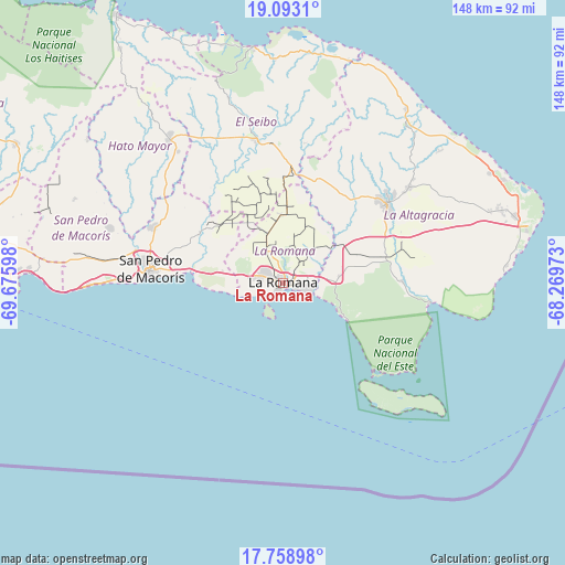
La Romana GPS coordinates[2]
18° 25' 38.388" North, 68° 58' 22.26" West
| Map corner | latitude | longitude |
|---|---|---|
| Upper-left | 19.0931°, | -69.67598° |
| Center: | 18.42733°, | -68.97285° |
| Lower-right: | 17.75898°, | -68.26973° |
| Map W x H: | 148.3×148.3 km | = 92.1×92.1mi |
| max Lat: | 19.89131° ⇑82.5% North |
| La Romana: | 18.42733° |
| min Lat: | ⇓17.5% South 17.80136° |
| min Long | La Romana | max Long |
| -71.85022° | -68.97285° | -68.40431° |
| W 97.6%⇐ | ⇒2.4% E |
Elevation
Elevation of La Romana is 30 m = 98 ft, and this is 136.3 m = 447 ft below average elevation for this country.
| Max E: |
1242 m = 4075 ft | 75.4% |
| Avg. | 166.3 m = 546 ft | |
| La Romana | 30 m = 98 ft | |
Min E: |
5 m = 16 ft | 24.6% |
See also: La Romana elevation on elevation.city.
Geographical zone
La Romana is located in North Torrid zone (between Equator and Tropic of Cancer). Distance of this Northern Tropic circle is 557 km =346.1 mi to North.| Distance of | km | miles | from La Romana |
|---|---|---|---|
| North Pole | 7958.1 | 4944.9 | to North |
| Arctic Circle | 5352.2 | 3325.7 | to North |
| Tropic Cancer | 557 | 346.1 | to North |
| Equator | 2048.9 | 1273.1 | to South |


Nearby cities:
15 places around La Romana: (largest is in red/bold)
• Boca de Yuma
38.8 km =24.1 mi,  98°
98°
• Guayabo Dulce
41 km =25.5 mi,  307°
307°
• Guaymate
17.9 km =11.1 mi,  358°
358°
• Hato Mayor del Rey
47.8 km =29.7 mi,  321°
321°
• Los Llanos
59.2 km =36.8 mi,  291°
291°
• Miches
62.4 km =38.8 mi,  352°
352°
• Otra Banda
41 km =25.5 mi,  52°
52°
• Pedro Sánchez
50.6 km =31.4 mi,  343°
343°
• Punta Cana
62.4 km =38.8 mi,  74°
74°
• Quisqueya
48.1 km =29.9 mi, 287°
• Ramón Santana
25.3 km =15.7 mi,  300°
300°
• Salvaleón de Higüey
34.9 km =21.7 mi, 53°
• San Pedro de Macorís
35.5 km =22.1 mi,  274°
274°
• San Rafael del Yuma
31.5 km =19.6 mi,  89°
89°
• Santa Cruz de El Seibo
38.2 km =23.7 mi, 349°
Sources, notices
• [Note1] Compared only with cities in Dominican Republic existing in our database
• [Src1] Map data: © OpenStreetMap contributors (CC-BY-SA)
• [Src2] Other city data from geonames.org with taken over terms of usage.
• [Src3] Geographical zone / Annual Mean Temperature by Robert A. Rohde @ Wikipedia
