Miches geodata
Miches (El Seíbo) is a populated place; located in Dominican Republic in America/Santo_Domingo (GMT-4) time zone. With population of 9,273 people, there are 72 cities with bigger population in this country. Compared to other cities in Dominican Republic, 54.5% of cities are located further ↓South; 96.2% of cities are located further ←West and 99.5% of cities have higher elevation than Miches. Note1
Administrative division(s):
- Level 1: El Seíbo
- Level 2: Miches
- Level 3: Miches
- Level 4: Miches (Zona Urbana)


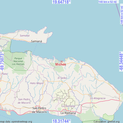
Miches GPS coordinates[2]
18° 59' 1.104" North, 69° 2' 51.36" West
| Map corner | latitude | longitude |
|---|---|---|
| Upper-left | 19.64718°, | -69.75073° |
| Center: | 18.98364°, | -69.0476° |
| Lower-right: | 18.31744°, | -68.34448° |
| Map W x H: | 147.9×147.9 km | = 91.9×91.9mi |
| max Lat: | 19.89131° ⇑45.5% North |
| Miches: | 18.98364° |
| min Lat: | ⇓54.5% South 17.80136° |
| min Long | Miches | max Long |
| -71.85022° | -69.0476° | -68.40431° |
| W 96.2%⇐ | ⇒3.8% E |
Elevation
Elevation of Miches is 6 m = 20 ft, and this is 160.3 m = 526 ft below average elevation for this country.
| Max E: |
1242 m = 4075 ft | 99.5% |
| Avg. | 166.3 m = 546 ft | |
| Miches | 6 m = 20 ft | |
Min E: |
5 m = 16 ft | 0.5% |
See also: Dominican Republic elevation on elevation.city.
Geographical zone
Miches is located in North Torrid zone (between Equator and Tropic of Cancer). Distance of this Northern Tropic circle is 495.1 km =307.6 mi to North.| Distance of | km | miles | from Miches |
|---|---|---|---|
| North Pole | 7896.3 | 4906.5 | to North |
| Arctic Circle | 5290.4 | 3287.3 | to North |
| Tropic Cancer | 495.1 | 307.6 | to North |
| Equator | 2110.8 | 1311.6 | to South |


Nearby cities:
15 places around Miches: (largest is in red/bold)
• El Puerto
49.4 km =30.7 mi,  243°
243°
• El Valle
34.8 km =21.6 mi,  268°
268°
• Guayabo Dulce
44.6 km =27.7 mi,  213°
213°
• Guaymate
44.6 km =27.7 mi,  170°
170°
• Hato Mayor del Rey
33 km =20.5 mi,  221°
221°
• La Romana
62.4 km =38.8 mi, 172°
• Los Llanos
62.1 km =38.6 mi,  229°
229°
• Otra Banda
54.9 km =34.1 mi,  132°
132°
• Pedro Sánchez
14.8 km =9.2 mi, 205°
• Quisqueya
60.9 km =37.8 mi, 218°
• Ramón Santana
51 km =31.7 mi,  195°
195°
• Sabana de la Mar
36.8 km =22.9 mi,  283°
283°
• Salvaleón de Higüey
54.4 km =33.8 mi,  138°
138°
• Samaná
39.2 km =24.4 mi,  309°
309°
• Santa Cruz de El Seibo
24.3 km =15.1 mi,  177°
177°
Sources, notices
• [Note1] Compared only with cities in Dominican Republic existing in our database
• [Src1] Map data: © OpenStreetMap contributors (CC-BY-SA)
• [Src2] Other city data from geonames.org with taken over terms of usage.
• [Src3] Geographical zone / Annual Mean Temperature by Robert A. Rohde @ Wikipedia
