Boca de Yuma geodata
Boca de Yuma (La Altagracia) is a populated place; located in Dominican Republic in America/Santo_Domingo (GMT-4) time zone. With population of 1,991 people, there are 177 cities with bigger population in this country. Compared to other cities in Dominican Republic, 86.7% of cities are located further ↑North; 99.5% of cities are located further ←West and 97.2% of cities have higher elevation than Boca de Yuma. Note1
Administrative division(s):
- Level 1: La Altagracia
- Level 2: San Rafael del Yuma
- Level 3: Boca De Yuma (D. M.).
- Level 4: Boca De Yuma (Zona Urbana)


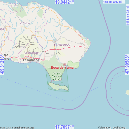
Boca de Yuma GPS coordinates[2]
18° 22' 41.7" North, 68° 36' 32.4" West
| Map corner | latitude | longitude |
|---|---|---|
| Upper-left | 19.04421°, | -69.31213° |
| Center: | 18.37825°, | -68.609° |
| Lower-right: | 17.70971°, | -67.90588° |
| Map W x H: | 148.4×148.4 km | = 92.2×92.2mi |
| max Lat: | 19.89131° ⇑86.7% North |
| Boca de Yuma: | 18.37825° |
| min Lat: | ⇓13.3% South 17.80136° |
| min Long | Boca de Yuma | max Long |
| -71.85022° | -68.609° | -68.40431° |
| W 99.5%⇐ | ⇒0.5% E |
Elevation
Elevation of Boca de Yuma is 8 m = 26 ft, and this is 158.3 m = 519 ft below average elevation for this country.
| Max E: |
1242 m = 4075 ft | 97.2% |
| Avg. | 166.3 m = 546 ft | |
| Boca de Yuma | 8 m = 26 ft | |
Min E: |
5 m = 16 ft | 2.8% |
See also: Dominican Republic elevation on elevation.city.
Geographical zone
Boca de Yuma is located in North Torrid zone (between Equator and Tropic of Cancer). Distance of this Northern Tropic circle is 562.4 km =349.5 mi to North.| Distance of | km | miles | from Boca de Yuma |
|---|---|---|---|
| North Pole | 7963.6 | 4948.4 | to North |
| Arctic Circle | 5357.7 | 3329.1 | to North |
| Tropic Cancer | 562.4 | 349.5 | to North |
| Equator | 2043.5 | 1269.8 | to South |


Nearby cities:
15 places around Boca de Yuma: (largest is in red/bold)
• Guayabo Dulce
77.3 km =48 mi,  293°
293°
• Guaymate
45.4 km =28.2 mi,  300°
300°
• Hato Mayor del Rey
80.6 km =50.1 mi, 302°
• La Romana
38.8 km =24.1 mi,  278°
278°
• Los Llanos
97.3 km =60.5 mi, 286°
• Miches
81.6 km =50.7 mi,  325°
325°
• Otra Banda
30.8 km =19.1 mi,  349°
349°
• Pedro Sánchez
75.4 km =46.9 mi,  315°
315°
• Punta Cana
31.3 km =19.4 mi,  43°
43°
• Quisqueya
86.6 km =53.8 mi, 283°
• Ramón Santana
62.9 km =39.1 mi, 286°
• Salvaleón de Higüey
28.3 km =17.6 mi,  338°
338°
• San Pedro de Macorís
74.3 km =46.2 mi, 276°
• San Rafael del Yuma
8.9 km =5.5 mi,  310°
310°
• Santa Cruz de El Seibo
62.5 km =38.8 mi, 313°
Sources, notices
• [Note1] Compared only with cities in Dominican Republic existing in our database
• [Src1] Map data: © OpenStreetMap contributors (CC-BY-SA)
• [Src2] Other city data from geonames.org with taken over terms of usage.
• [Src3] Geographical zone / Annual Mean Temperature by Robert A. Rohde @ Wikipedia
