Khemis Miliana geodata
Khemis Miliana (Aïn Defla) is a populated place; located in Algeria in Africa/Algiers (GMT+1) time zone. With population of 75,865 people, there are 51 cities with bigger population in this country. Compared to other cities in Algeria, 57.4% of cities are located further ↓South; 70.5% of cities are located further →East and 50% of cities have lower elevation than Khemis Miliana. Note1


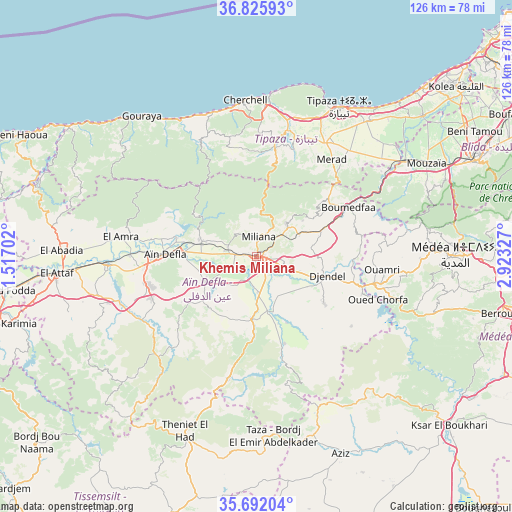
Khemis Miliana GPS coordinates[2]
36° 15' 39.744" North, 2° 13' 12.54" East
| Map corner | latitude | longitude |
|---|---|---|
| Upper-left | 36.82593°, | 1.51702° |
| Center: | 36.26104°, | 2.22015° |
| Lower-right: | 35.69204°, | 2.92327° |
| Map W x H: | 126.1×126.1 km | = 78.4×78.4mi |
| max Lat: | 36.92917° ⇑42.6% North |
| Khemis Miliana: | 36.26104° |
| min Lat: | ⇓57.4% South 22.785° |
| min Long | Khemis Miliana | max Long |
| -8.14743° | 2.22015° | 8.46667° |
| W 29.5%⇐ | ⇒70.5% E |
Elevation
Elevation of Khemis Miliana is 299 m = 981 ft, and this is 139.5 m = 458 ft below average elevation for this country.
| Max E: |
1392 m = 4567 ft | 50% |
| Avg. | 438.5 m = 1439 ft | |
| Khemis Miliana | 299 m = 981 ft | |
Min E: |
5 m = 16 ft | 50% |
See also: Khemis Miliana elevation on elevation.city.
Geographical zone
Khemis Miliana is located in North temperate zone (between Tropic of Cancer and the Arctic Circle). Distance of this Northern Tropic circle is 1425.9 km =886 mi to South.| Distance of | km | miles | from Khemis Miliana |
|---|---|---|---|
| North Pole | 5975.2 | 3712.8 | to North |
| Arctic Circle | 3369.3 | 2093.6 | to North |
| Tropic Cancer | 1425.9 | 886 | to South |
| Equator | 4031.8 | 2505.2 | to South |


Nearby cities:
15 places around Khemis Miliana: (largest is in red/bold)
• Aïn Defla
22.6 km =14 mi,  270°
270°
• Blida
59.2 km =36.8 mi,  66°
66°
• Bou Ismaïl
59.7 km =37.1 mi,  44°
44°
• Boû Arfa
57.8 km =35.9 mi, 67°
• Chiffa
51.6 km =32.1 mi,  64°
64°
• Commune des Béni Bou Attab
61.7 km =38.3 mi,  241°
241°
• El Abadia
47.9 km =29.8 mi, 271°
• El Affroun
43.1 km =26.8 mi, 57°
• El Attaf
49.3 km =30.6 mi, 265°
• Hadjout
32.9 km =20.4 mi,  31°
31°
• Mouzaïa
47.9 km =29.8 mi, 61°
• Médéa
47.9 km =29.8 mi,  89°
89°
• Oued el Alleug
60.6 km =37.7 mi, 57°
• Theniet el Had
46.7 km =29 mi,  201°
201°
• Tipasa
41.8 km =26 mi, 29°
Sources, notices
• [Note1] Compared only with cities in Algeria existing in our database
• [Src1] Map data: © OpenStreetMap contributors (CC-BY-SA)
• [Src2] Other city data from geonames.org with taken over terms of usage.
• [Src3] Geographical zone / Annual Mean Temperature by Robert A. Rohde @ Wikipedia
