Aïn Defla geodata
Aïn Defla is a seat of a first-order administrative division; located in Algeria in Africa/Algiers (GMT+1) time zone. With population of 52,276 people, there are 95 cities with bigger population in this country. Compared to other cities in Algeria, 58.1% of cities are located further ↓South; 71.7% of cities are located further →East and 53.1% of cities have higher elevation than Aïn Defla. Note1


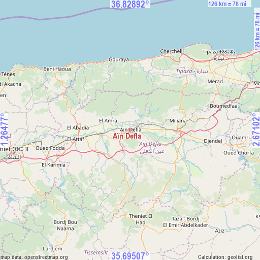
Aïn Defla GPS coordinates[2]
36° 15' 50.58" North, 1° 58' 4.44" East
| Map corner | latitude | longitude |
|---|---|---|
| Upper-left | 36.82892°, | 1.26477° |
| Center: | 36.26405°, | 1.9679° |
| Lower-right: | 35.69507°, | 2.67102° |
| Map W x H: | 126.1×126.1 km | = 78.4×78.4mi |
| max Lat: | 36.92917° ⇑41.9% North |
| Aïn Defla: | 36.26405° |
| min Lat: | ⇓58.1% South 22.785° |
| min Long | Aïn Defla | max Long |
| -8.14743° | 1.9679° | 8.46667° |
| W 28.3%⇐ | ⇒71.7% E |
Elevation
Elevation of Aïn Defla is 264 m = 866 ft, and this is 174.5 m = 573 ft below average elevation for this country.
| Max E: |
1392 m = 4567 ft | 53.1% |
| Avg. | 438.5 m = 1439 ft | |
| Aïn Defla | 264 m = 866 ft | |
Min E: |
5 m = 16 ft | 46.9% |
See also: Aïn Defla elevation on elevation.city.
Geographical zone
Aïn Defla is located in North temperate zone (between Tropic of Cancer and the Arctic Circle). Distance of this Northern Tropic circle is 1426.3 km =886.3 mi to South.| Distance of | km | miles | from Aïn Defla |
|---|---|---|---|
| North Pole | 5974.9 | 3712.6 | to North |
| Arctic Circle | 3369 | 2093.4 | to North |
| Tropic Cancer | 1426.3 | 886.3 | to South |
| Equator | 4032.2 | 2505.5 | to South |


Nearby cities:
15 places around Aïn Defla: (largest is in red/bold)
• Chlef
57.9 km =36 mi,  259°
259°
• Commune des Béni Bou Attab
43.4 km =27 mi,  226°
226°
• Ech Chettia
64.4 km =40 mi, 263°
• El Abadia
25.3 km =15.7 mi,  271°
271°
• El Affroun
63.2 km =39.3 mi,  68°
68°
• El Attaf
26.9 km =16.7 mi, 260°
• Hadjout
48.5 km =30.1 mi,  55°
55°
• Khemis Miliana
22.6 km =14 mi,  90°
90°
• Lardjem
68.6 km =42.6 mi,  213°
213°
• Mouzaïa
68.5 km =42.6 mi, 70°
• Médéa
70.5 km =43.8 mi, 89°
• Oued Fodda
40 km =24.9 mi, 257°
• Sidi Akkacha
63.6 km =39.5 mi,  290°
290°
• Theniet el Had
44 km =27.3 mi,  172°
172°
• Tipasa
56.1 km =34.9 mi,  49°
49°
Sources, notices
• [Note1] Compared only with cities in Algeria existing in our database
• [Src1] Map data: © OpenStreetMap contributors (CC-BY-SA)
• [Src2] Other city data from geonames.org with taken over terms of usage.
• [Src3] Geographical zone / Annual Mean Temperature by Robert A. Rohde @ Wikipedia
