Hadjout geodata
Hadjout (Tipaza) is a populated place; located in Algeria in Africa/Algiers (GMT+1) time zone. With population of 27,549 people, there are 189 cities with bigger population in this country. Compared to other cities in Algeria, 69% of cities are located further ↓South; 69.8% of cities are located further →East and 79.1% of cities have higher elevation than Hadjout. Note1


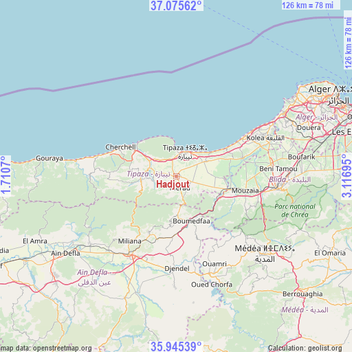
Hadjout GPS coordinates[2]
36° 30' 45.252" North, 2° 24' 49.752" East
| Map corner | latitude | longitude |
|---|---|---|
| Upper-left | 37.07562°, | 1.7107° |
| Center: | 36.51257°, | 2.41382° |
| Lower-right: | 35.94539°, | 3.11695° |
| Map W x H: | 125.7×125.7 km | = 78.1×78.1mi |
| max Lat: | 36.92917° ⇑31% North |
| Hadjout: | 36.51257° |
| min Lat: | ⇓69% South 22.785° |
| min Long | Hadjout | max Long |
| -8.14743° | 2.41382° | 8.46667° |
| W 30.2%⇐ | ⇒69.8% E |
Elevation
Elevation of Hadjout is 88 m = 289 ft, and this is 350.5 m = 1150 ft below average elevation for this country.
| Max E: |
1392 m = 4567 ft | 79.1% |
| Avg. | 438.5 m = 1439 ft | |
| Hadjout | 88 m = 289 ft | |
Min E: |
5 m = 16 ft | 20.9% |
See also: Algeria elevation on elevation.city.
Geographical zone
Hadjout is located in North temperate zone (between Tropic of Cancer and the Arctic Circle). Distance of this Northern Tropic circle is 1453.9 km =903.4 mi to South.| Distance of | km | miles | from Hadjout |
|---|---|---|---|
| North Pole | 5947.2 | 3695.4 | to North |
| Arctic Circle | 3341.4 | 2076.2 | to North |
| Tropic Cancer | 1453.9 | 903.4 | to South |
| Equator | 4059.8 | 2522.6 | to South |


Nearby cities:
15 places around Hadjout: (largest is in red/bold)
• Beni Mered
40 km =24.9 mi,  88°
88°
• Blida
37.3 km =23.2 mi,  97°
97°
• Bou Ismaïl
28.6 km =17.8 mi,  59°
59°
• Boufarik
45 km =28 mi,  81°
81°
• Boû Arfa
36.3 km =22.6 mi, 98°
• Chiffa
29.6 km =18.4 mi, 100°
• El Affroun
19.5 km =12.1 mi, 104°
• Khemis Miliana
32.9 km =20.4 mi,  211°
211°
• Kolea
34.6 km =21.5 mi,  66°
66°
• Mouzaïa
25.2 km =15.7 mi, 101°
• Médéa
41.1 km =25.5 mi,  132°
132°
• Oued el Alleug
34 km =21.1 mi, 81°
• Souma
43.9 km =27.3 mi, 89°
• Tipasa
9.1 km =5.7 mi,  19°
19°
• Zeralda
44.2 km =27.5 mi, 59°
Sources, notices
• [Note1] Compared only with cities in Algeria existing in our database
• [Src1] Map data: © OpenStreetMap contributors (CC-BY-SA)
• [Src2] Other city data from geonames.org with taken over terms of usage.
• [Src3] Geographical zone / Annual Mean Temperature by Robert A. Rohde @ Wikipedia
