Bou Ismaïl geodata
Bou Ismaïl (Tipaza) is a populated place; located in Algeria in Africa/Algiers (GMT+1) time zone. With population of 22,411 people, there are 213 cities with bigger population in this country. Compared to other cities in Algeria, 80.6% of cities are located further ↓South; 67.4% of cities are located further →East and 92.6% of cities have higher elevation than Bou Ismaïl. Note1


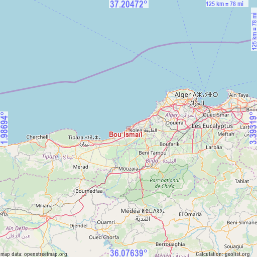
Bou Ismaïl GPS coordinates[2]
36° 38' 33.432" North, 2° 41' 24.252" East
| Map corner | latitude | longitude |
|---|---|---|
| Upper-left | 37.20472°, | 1.98694° |
| Center: | 36.64262°, | 2.69007° |
| Lower-right: | 36.07639°, | 3.39319° |
| Map W x H: | 125.5×125.5 km | = 78×78mi |
| max Lat: | 36.92917° ⇑19.4% North |
| Bou Ismaïl: | 36.64262° |
| min Lat: | ⇓80.6% South 22.785° |
| min Long | Bou Ismaïl | max Long |
| -8.14743° | 2.69007° | 8.46667° |
| W 32.6%⇐ | ⇒67.4% E |
Elevation
Elevation of Bou Ismaïl is 29 m = 95 ft, and this is 409.5 m = 1344 ft below average elevation for this country.
| Max E: |
1392 m = 4567 ft | 92.6% |
| Avg. | 438.5 m = 1439 ft | |
| Bou Ismaïl | 29 m = 95 ft | |
Min E: |
5 m = 16 ft | 7.4% |
See also: Algeria elevation on elevation.city.
Geographical zone
Bou Ismaïl is located in North temperate zone (between Tropic of Cancer and the Arctic Circle). Distance of this Northern Tropic circle is 1468.4 km =912.4 mi to South.| Distance of | km | miles | from Bou Ismaïl |
|---|---|---|---|
| North Pole | 5932.8 | 3686.5 | to North |
| Arctic Circle | 3326.9 | 2067.2 | to North |
| Tropic Cancer | 1468.4 | 912.4 | to South |
| Equator | 4074.3 | 2531.7 | to South |


Nearby cities:
15 places around Bou Ismaïl: (largest is in red/bold)
• Beni Mered
20.2 km =12.6 mi,  130°
130°
• Blida
22.8 km =14.2 mi,  147°
147°
• Boufarik
21.2 km =13.2 mi,  111°
111°
• Boû Arfa
22.9 km =14.2 mi, 150°
• Cheraga
27.7 km =17.2 mi,  59°
59°
• Chiffa
20.4 km =12.7 mi,  167°
167°
• Douera
22.9 km =14.2 mi,  82°
82°
• El Affroun
20 km =12.4 mi,  196°
196°
• Kolea
7 km =4.3 mi,  93°
93°
• Mouzaïa
19.5 km =12.1 mi,  180°
180°
• Oued el Alleug
13.2 km =8.2 mi,  137°
137°
• Souma
23.7 km =14.7 mi, 125°
• Tipasa
22.4 km =13.9 mi,  254°
254°
• Zeralda
15.6 km =9.7 mi, 60°
• ’Aïn Benian
27.3 km =17 mi,  49°
49°
Sources, notices
• [Note1] Compared only with cities in Algeria existing in our database
• [Src1] Map data: © OpenStreetMap contributors (CC-BY-SA)
• [Src2] Other city data from geonames.org with taken over terms of usage.
• [Src3] Geographical zone / Annual Mean Temperature by Robert A. Rohde @ Wikipedia
