Tipasa geodata
Tipasa (Tipaza) is a seat of a first-order administrative division; located in Algeria in Africa/Algiers (GMT+1) time zone. With population of 25,225 people, there are 201 cities with bigger population in this country. Compared to other cities in Algeria, 76.7% of cities are located further ↓South; 69.4% of cities are located further →East and 90.7% of cities have higher elevation than Tipasa. Note1


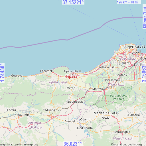
Tipasa GPS coordinates[2]
36° 35' 22.992" North, 2° 26' 51" East
| Map corner | latitude | longitude |
|---|---|---|
| Upper-left | 37.15221°, | 1.74438° |
| Center: | 36.58972°, | 2.4475° |
| Lower-right: | 36.0231°, | 3.15063° |
| Map W x H: | 125.5×125.5 km | = 78×78mi |
| max Lat: | 36.92917° ⇑23.3% North |
| Tipasa: | 36.58972° |
| min Lat: | ⇓76.7% South 22.785° |
| min Long | Tipasa | max Long |
| -8.14743° | 2.4475° | 8.46667° |
| W 30.6%⇐ | ⇒69.4% E |
Elevation
Elevation of Tipasa is 32 m = 105 ft, and this is 406.5 m = 1334 ft below average elevation for this country.
| Max E: |
1392 m = 4567 ft | 90.7% |
| Avg. | 438.5 m = 1439 ft | |
| Tipasa | 32 m = 105 ft | |
Min E: |
5 m = 16 ft | 9.3% |
See also: Algeria elevation on elevation.city.
Geographical zone
Tipasa is located in North temperate zone (between Tropic of Cancer and the Arctic Circle). Distance of this Northern Tropic circle is 1462.5 km =908.8 mi to South.| Distance of | km | miles | from Tipasa |
|---|---|---|---|
| North Pole | 5938.7 | 3690.1 | to North |
| Arctic Circle | 3332.8 | 2070.9 | to North |
| Tropic Cancer | 1462.5 | 908.8 | to South |
| Equator | 4068.4 | 2528 | to South |


Nearby cities:
15 places around Tipasa: (largest is in red/bold)
• Beni Mered
37.7 km =23.4 mi,  101°
101°
• Blida
36.5 km =22.7 mi,  111°
111°
• Bou Ismaïl
22.4 km =13.9 mi,  74°
74°
• Boufarik
41.5 km =25.8 mi,  92°
92°
• Boû Arfa
35.7 km =22.2 mi, 113°
• Chiffa
29.6 km =18.4 mi,  118°
118°
• Douera
45.2 km =28.1 mi,  78°
78°
• El Affroun
20.7 km =12.9 mi,  129°
129°
• Hadjout
9.1 km =5.7 mi,  199°
199°
• Khemis Miliana
41.8 km =26 mi,  209°
209°
• Kolea
29.2 km =18.1 mi, 79°
• Mouzaïa
25.6 km =15.9 mi, 122°
• Oued el Alleug
30.8 km =19.1 mi, 97°
• Souma
41.7 km =25.9 mi, 100°
• Zeralda
37.8 km =23.5 mi, 68°
Sources, notices
• [Note1] Compared only with cities in Algeria existing in our database
• [Src1] Map data: © OpenStreetMap contributors (CC-BY-SA)
• [Src2] Other city data from geonames.org with taken over terms of usage.
• [Src3] Geographical zone / Annual Mean Temperature by Robert A. Rohde @ Wikipedia
