Médéa geodata
Médéa (Medea) is a seat of a first-order administrative division; located in Algeria in Africa/Algiers (GMT+1) time zone. With population of 147,707 people, there are 23 cities with bigger population in this country. Compared to other cities in Algeria, 58.5% of cities are located further ↓South; 66.3% of cities are located further →East and 84.1% of cities have lower elevation than Médéa. Note1


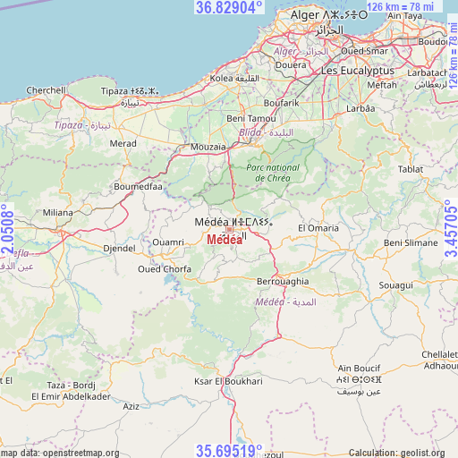
Médéa GPS coordinates[2]
36° 15' 51.012" North, 2° 45' 14.148" East
| Map corner | latitude | longitude |
|---|---|---|
| Upper-left | 36.82904°, | 2.0508° |
| Center: | 36.26417°, | 2.75393° |
| Lower-right: | 35.69519°, | 3.45705° |
| Map W x H: | 126.1×126.1 km | = 78.4×78.4mi |
| max Lat: | 36.92917° ⇑41.5% North |
| Médéa: | 36.26417° |
| min Lat: | ⇓58.5% South 22.785° |
| min Long | Médéa | max Long |
| -8.14743° | 2.75393° | 8.46667° |
| W 33.7%⇐ | ⇒66.3% E |
Elevation
Elevation of Médéa is 910 m = 2986 ft, and this is 471.5 m = 1547 ft above average elevation for this country.
| Max E: |
1392 m = 4567 ft | 15.9% |
| Médéa | 910 m 2986 ft | |
| Avg. | 438.5 m = 1439 ft | |
Min E: |
5 m = 16 ft | 84.1% |
See also: Médéa elevation on elevation.city.
Geographical zone
Médéa is located in North temperate zone (between Tropic of Cancer and the Arctic Circle). Distance of this Northern Tropic circle is 1426.3 km =886.3 mi to South.| Distance of | km | miles | from Médéa |
|---|---|---|---|
| North Pole | 5974.9 | 3712.6 | to North |
| Arctic Circle | 3369 | 2093.4 | to North |
| Tropic Cancer | 1426.3 | 886.3 | to South |
| Equator | 4032.2 | 2505.5 | to South |


Nearby cities:
15 places around Médéa: (largest is in red/bold)
• Beni Mered
30.4 km =18.9 mi,  18°
18°
• Berrouaghia
20.1 km =12.5 mi,  135°
135°
• Blida
23.8 km =14.8 mi, 16°
• Boufarik
37.3 km =23.2 mi, 22°
• Bouinan
36.6 km =22.7 mi,  35°
35°
• Boû Arfa
22.8 km =14.2 mi,  13°
13°
• Chebli
41.6 km =25.8 mi,  33°
33°
• Chiffa
22.1 km =13.7 mi,  356°
356°
• El Affroun
25.6 km =15.9 mi,  333°
333°
• Hadjout
41.1 km =25.5 mi,  312°
312°
• Kolea
41.7 km =25.9 mi,  1°
1°
• Ksar el Boukhari
41.7 km =25.9 mi,  180°
180°
• Mouzaïa
23.3 km =14.5 mi,  345°
345°
• Oued el Alleug
32.5 km =20.2 mi, 5°
• Souma
31.3 km =19.4 mi, 25°
Sources, notices
• [Note1] Compared only with cities in Algeria existing in our database
• [Src1] Map data: © OpenStreetMap contributors (CC-BY-SA)
• [Src2] Other city data from geonames.org with taken over terms of usage.
• [Src3] Geographical zone / Annual Mean Temperature by Robert A. Rohde @ Wikipedia
