Chlef geodata
Chlef is a seat of a first-order administrative division; located in Algeria in Africa/Algiers (GMT+1) time zone. With population of 178,616 people, there are 13 cities with bigger population in this country. Compared to other cities in Algeria, 54.7% of cities are located further ↓South; 75.6% of cities are located further →East and 69.8% of cities have higher elevation than Chlef. Note1


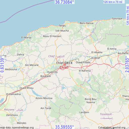
Chlef GPS coordinates[2]
36° 9' 54.9" North, 1° 20' 4.272" East
| Map corner | latitude | longitude |
|---|---|---|
| Upper-left | 36.73084°, | 0.63139° |
| Center: | 36.16525°, | 1.33452° |
| Lower-right: | 35.59555°, | 2.03765° |
| Map W x H: | 126.2×126.2 km | = 78.4×78.4mi |
| max Lat: | 36.92917° ⇑45.3% North |
| Chlef: | 36.16525° |
| min Lat: | ⇓54.7% South 22.785° |
| min Long | Chlef | max Long |
| -8.14743° | 1.33452° | 8.46667° |
| W 24.4%⇐ | ⇒75.6% E |
Elevation
Elevation of Chlef is 116 m = 381 ft, and this is 322.5 m = 1058 ft below average elevation for this country.
| Max E: |
1392 m = 4567 ft | 69.8% |
| Avg. | 438.5 m = 1439 ft | |
| Chlef | 116 m = 381 ft | |
Min E: |
5 m = 16 ft | 30.2% |
See also: Chlef elevation on elevation.city.
Geographical zone
Chlef is located in North temperate zone (between Tropic of Cancer and the Arctic Circle). Distance of this Northern Tropic circle is 1415.3 km =879.4 mi to South.| Distance of | km | miles | from Chlef |
|---|---|---|---|
| North Pole | 5985.9 | 3719.5 | to North |
| Arctic Circle | 3380 | 2100.2 | to North |
| Tropic Cancer | 1415.3 | 879.4 | to South |
| Equator | 4021.2 | 2498.7 | to South |


Nearby cities:
15 places around Chlef: (largest is in red/bold)
• Abou el Hassan
30.6 km =19 mi,  336°
336°
• Ammi Moussa
38.7 km =24 mi,  211°
211°
• Boukadir
21.7 km =13.5 mi,  239°
239°
• Commune des Béni Bou Attab
31.7 km =19.7 mi,  126°
126°
• Djidiouia
52.5 km =32.6 mi, 240°
• Ech Chettia
7.9 km =4.9 mi,  295°
295°
• El Abadia
33.6 km =20.9 mi,  69°
69°
• El Attaf
31 km =19.3 mi,  77°
77°
• Lardjem
50.1 km =31.1 mi,  157°
157°
• Mazouna
39.4 km =24.5 mi,  263°
263°
• Oued Fodda
17.9 km =11.1 mi, 82°
• Oued Rhiou
43.7 km =27.2 mi, 238°
• Oued Sly
14.1 km =8.8 mi, 239°
• Sidi Akkacha
33.4 km =20.8 mi,  355°
355°
• ’Aïn Merane
32.7 km =20.3 mi,  269°
269°
Sources, notices
• [Note1] Compared only with cities in Algeria existing in our database
• [Src1] Map data: © OpenStreetMap contributors (CC-BY-SA)
• [Src2] Other city data from geonames.org with taken over terms of usage.
• [Src3] Geographical zone / Annual Mean Temperature by Robert A. Rohde @ Wikipedia
