Ammi Moussa geodata
Ammi Moussa (Relizane) is a populated place; located in Algeria in Africa/Algiers (GMT+1) time zone. With population of 23,001 people, there are 211 cities with bigger population in this country. Compared to other cities in Algeria, 56.2% of cities are located further ↑North; 78.7% of cities are located further →East and 63.6% of cities have higher elevation than Ammi Moussa. Note1


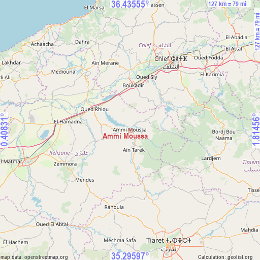
Ammi Moussa GPS coordinates[2]
35° 52' 4.116" North, 1° 6' 41.148" East
| Map corner | latitude | longitude |
|---|---|---|
| Upper-left | 36.43555°, | 0.40831° |
| Center: | 35.86781°, | 1.11143° |
| Lower-right: | 35.29597°, | 1.81456° |
| Map W x H: | 126.7×126.7 km | = 78.7×78.7mi |
| max Lat: | 36.92917° ⇑56.2% North |
| Ammi Moussa: | 35.86781° |
| min Lat: | ⇓43.8% South 22.785° |
| min Long | Ammi Moussa | max Long |
| -8.14743° | 1.11143° | 8.46667° |
| W 21.3%⇐ | ⇒78.7% E |
Elevation
Elevation of Ammi Moussa is 157 m = 515 ft, and this is 281.5 m = 924 ft below average elevation for this country.
| Max E: |
1392 m = 4567 ft | 63.6% |
| Avg. | 438.5 m = 1439 ft | |
| Ammi Moussa | 157 m = 515 ft | |
Min E: |
5 m = 16 ft | 36.4% |
See also: Algeria elevation on elevation.city.
Geographical zone
Ammi Moussa is located in North temperate zone (between Tropic of Cancer and the Arctic Circle). Distance of this Northern Tropic circle is 1382.2 km =858.9 mi to South.| Distance of | km | miles | from Ammi Moussa |
|---|---|---|---|
| North Pole | 6018.9 | 3740 | to North |
| Arctic Circle | 3413 | 2120.7 | to North |
| Tropic Cancer | 1382.2 | 858.9 | to South |
| Equator | 3988.1 | 2478.1 | to South |


Nearby cities:
15 places around Ammi Moussa: (largest is in red/bold)
• Boukadir
22.1 km =13.7 mi,  3°
3°
• Chlef
38.7 km =24 mi,  31°
31°
• Commune des Béni Bou Attab
47.7 km =29.6 mi,  72°
72°
• Djidiouia
26.4 km =16.4 mi,  285°
285°
• Ech Chettia
38.7 km =24 mi,  19°
19°
• Lardjem
41.5 km =25.8 mi,  108°
108°
• Mazouna
34.2 km =21.3 mi,  325°
325°
• Oued Fodda
51.8 km =32.2 mi,  47°
47°
• Oued Rhiou
20.2 km =12.6 mi,  300°
300°
• Oued Sly
27.1 km =16.8 mi, 16°
• Relizane
52.1 km =32.4 mi,  253°
253°
• Rouachdia
38.7 km =24 mi,  242°
242°
• Smala
36.3 km =22.6 mi, 242°
• Zemoura
36 km =22.4 mi, 243°
• ’Aïn Merane
35.2 km =21.9 mi,  338°
338°
Sources, notices
• [Note1] Compared only with cities in Algeria existing in our database
• [Src1] Map data: © OpenStreetMap contributors (CC-BY-SA)
• [Src2] Other city data from geonames.org with taken over terms of usage.
• [Src3] Geographical zone / Annual Mean Temperature by Robert A. Rohde @ Wikipedia
