’Aïn Merane geodata
’Aïn Merane (Relizane) is a populated place; located in Algeria in Africa/Algiers (GMT+1) time zone. With population of 34,413 people, there are 149 cities with bigger population in this country. Compared to other cities in Algeria, 53.9% of cities are located further ↓South; 80.2% of cities are located further →East and 60.9% of cities have lower elevation than ’Aïn Merane. Note1


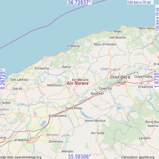
’Aïn Merane GPS coordinates[2]
36° 9' 45.972" North, 0° 58' 13.332" East
| Map corner | latitude | longitude |
|---|---|---|
| Upper-left | 36.72837°, | 0.26725° |
| Center: | 36.16277°, | 0.97037° |
| Lower-right: | 35.59306°, | 1.6735° |
| Map W x H: | 126.2×126.2 km | = 78.4×78.4mi |
| max Lat: | 36.92917° ⇑46.1% North |
| ’Aïn Merane: | 36.16277° |
| min Lat: | ⇓53.9% South 22.785° |
| min Long | ’Aïn Merane | max Long |
| -8.14743° | 0.97037° | 8.46667° |
| W 19.8%⇐ | ⇒80.2% E |
Elevation
Elevation of ’Aïn Merane is 504 m = 1654 ft, and this is 65.5 m = 215 ft above average elevation for this country.
| Max E: |
1392 m = 4567 ft | 39.1% |
| ’Aïn Merane | 504 m 1654 ft | |
| Avg. | 438.5 m = 1439 ft | |
Min E: |
5 m = 16 ft | 60.9% |
See also: Algeria elevation on elevation.city.
Geographical zone
’Aïn Merane is located in North temperate zone (between Tropic of Cancer and the Arctic Circle). Distance of this Northern Tropic circle is 1415 km =879.2 mi to South.| Distance of | km | miles | from ’Aïn Merane |
|---|---|---|---|
| North Pole | 5986.1 | 3719.6 | to North |
| Arctic Circle | 3380.3 | 2100.4 | to North |
| Tropic Cancer | 1415 | 879.2 | to South |
| Equator | 4020.9 | 2498.5 | to South |


Nearby cities:
15 places around ’Aïn Merane: (largest is in red/bold)
• Abou el Hassan
34.7 km =21.6 mi,  35°
35°
• Ammi Moussa
35.2 km =21.9 mi,  158°
158°
• Boukadir
17.6 km =10.9 mi,  127°
127°
• Chlef
32.7 km =20.3 mi,  89°
89°
• Djidiouia
28.9 km =18 mi,  206°
206°
• Ech Chettia
25.8 km =16 mi,  81°
81°
• Mazouna
7.9 km =4.9 mi,  235°
235°
• Oued Fodda
50.6 km =31.4 mi, 87°
• Oued Rhiou
22.9 km =14.2 mi,  191°
191°
• Oued Sly
21.7 km =13.5 mi,  108°
108°
• Relizane
60.2 km =37.4 mi,  218°
218°
• Rouachdia
54.9 km =34.1 mi,  203°
203°
• Sidi Akkacha
44.9 km =27.9 mi, 41°
• Smala
53.3 km =33.1 mi, 201°
• Zemoura
52.6 km =32.7 mi, 201°
Sources, notices
• [Note1] Compared only with cities in Algeria existing in our database
• [Src1] Map data: © OpenStreetMap contributors (CC-BY-SA)
• [Src2] Other city data from geonames.org with taken over terms of usage.
• [Src3] Geographical zone / Annual Mean Temperature by Robert A. Rohde @ Wikipedia
