Lardjem geodata
Lardjem (Tissemsilt) is a populated place; located in Algeria in Africa/Algiers (GMT+1) time zone. With population of 30,000 people, there are 174 cities with bigger population in this country. Compared to other cities in Algeria, 58.1% of cities are located further ↑North; 74% of cities are located further →East and 64.3% of cities have lower elevation than Lardjem. Note1


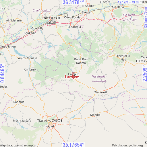
Lardjem GPS coordinates[2]
35° 44' 57.192" North, 1° 32' 52.008" East
| Map corner | latitude | longitude |
|---|---|---|
| Upper-left | 36.31781°, | 0.84465° |
| Center: | 35.74922°, | 1.54778° |
| Lower-right: | 35.17654°, | 2.2509° |
| Map W x H: | 126.9×126.9 km | = 78.9×78.9mi |
| max Lat: | 36.92917° ⇑58.1% North |
| Lardjem: | 35.74922° |
| min Lat: | ⇓41.9% South 22.785° |
| min Long | Lardjem | max Long |
| -8.14743° | 1.54778° | 8.46667° |
| W 26%⇐ | ⇒74% E |
Elevation
Elevation of Lardjem is 552 m = 1811 ft, and this is 113.5 m = 372 ft above average elevation for this country.
| Max E: |
1392 m = 4567 ft | 35.7% |
| Lardjem | 552 m 1811 ft | |
| Avg. | 438.5 m = 1439 ft | |
Min E: |
5 m = 16 ft | 64.3% |
See also: Algeria elevation on elevation.city.
Geographical zone
Lardjem is located in North temperate zone (between Tropic of Cancer and the Arctic Circle). Distance of this Northern Tropic circle is 1369 km =850.7 mi to South.| Distance of | km | miles | from Lardjem |
|---|---|---|---|
| North Pole | 6032.1 | 3748.2 | to North |
| Arctic Circle | 3426.2 | 2128.9 | to North |
| Tropic Cancer | 1369 | 850.7 | to South |
| Equator | 3974.9 | 2469.9 | to South |


Nearby cities:
15 places around Lardjem: (largest is in red/bold)
• Ammi Moussa
41.5 km =25.8 mi,  288°
288°
• Boukadir
51.8 km =32.2 mi,  312°
312°
• Chlef
50.1 km =31.1 mi,  337°
337°
• Commune des Béni Bou Attab
28 km =17.4 mi,  12°
12°
• Ech Chettia
56.2 km =34.9 mi,  332°
332°
• El Abadia
59.2 km =36.8 mi, 12°
• El Attaf
54 km =33.6 mi, 11°
• Mehdia daira de meghila
40.2 km =25 mi,  151°
151°
• Oued Fodda
48.5 km =30.1 mi,  358°
358°
• Oued Rhiou
61.4 km =38.2 mi, 292°
• Oued Sly
50.2 km =31.2 mi,  321°
321°
• Sougueur
62.8 km =39 mi,  184°
184°
• Theniet el Had
45.4 km =28.2 mi,  72°
72°
• Tiaret
46.9 km =29.1 mi,  206°
206°
• Tissemsilt
28.5 km =17.7 mi,  123°
123°
Sources, notices
• [Note1] Compared only with cities in Algeria existing in our database
• [Src1] Map data: © OpenStreetMap contributors (CC-BY-SA)
• [Src2] Other city data from geonames.org with taken over terms of usage.
• [Src3] Geographical zone / Annual Mean Temperature by Robert A. Rohde @ Wikipedia
