Oued Rhiou geodata
Oued Rhiou (Relizane) is a populated place; located in Algeria in Africa/Algiers (GMT+1) time zone. With population of 59,864 people, there are 78 cities with bigger population in this country. Compared to other cities in Algeria, 51.9% of cities are located further ↑North; 80.6% of cities are located further →East and 74.8% of cities have higher elevation than Oued Rhiou. Note1


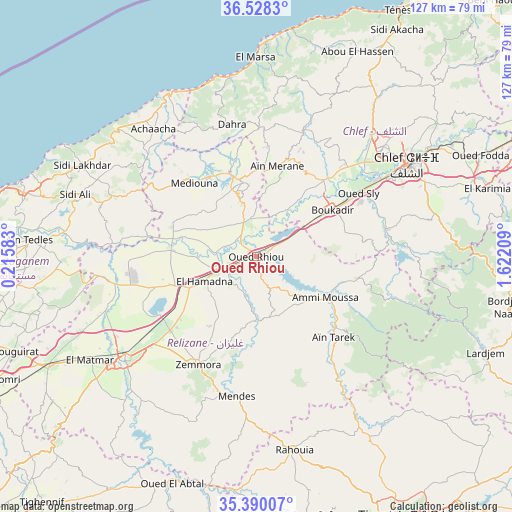
Oued Rhiou GPS coordinates[2]
35° 57' 40.464" North, 0° 55' 8.256" East
| Map corner | latitude | longitude |
|---|---|---|
| Upper-left | 36.5283°, | 0.21583° |
| Center: | 35.96124°, | 0.91896° |
| Lower-right: | 35.39007°, | 1.62209° |
| Map W x H: | 126.6×126.6 km | = 78.7×78.7mi |
| max Lat: | 36.92917° ⇑51.9% North |
| Oued Rhiou: | 35.96124° |
| min Lat: | ⇓48.1% South 22.785° |
| min Long | Oued Rhiou | max Long |
| -8.14743° | 0.91896° | 8.46667° |
| W 19.4%⇐ | ⇒80.6% E |
Elevation
Elevation of Oued Rhiou is 97 m = 318 ft, and this is 341.5 m = 1120 ft below average elevation for this country.
| Max E: |
1392 m = 4567 ft | 74.8% |
| Avg. | 438.5 m = 1439 ft | |
| Oued Rhiou | 97 m = 318 ft | |
Min E: |
5 m = 16 ft | 25.2% |
See also: Oued Rhiou elevation on elevation.city.
Geographical zone
Oued Rhiou is located in North temperate zone (between Tropic of Cancer and the Arctic Circle). Distance of this Northern Tropic circle is 1392.6 km =865.3 mi to South.| Distance of | km | miles | from Oued Rhiou |
|---|---|---|---|
| North Pole | 6008.5 | 3733.5 | to North |
| Arctic Circle | 3402.7 | 2114.3 | to North |
| Tropic Cancer | 1392.6 | 865.3 | to South |
| Equator | 3998.5 | 2484.6 | to South |


Nearby cities:
15 places around Oued Rhiou: (largest is in red/bold)
• Abou el Hassan
56.4 km =35 mi,  26°
26°
• Ammi Moussa
20.2 km =12.6 mi,  120°
120°
• Boukadir
22 km =13.7 mi,  57°
57°
• Chlef
43.7 km =27.2 mi, 58°
• Djidiouia
8.8 km =5.5 mi,  246°
246°
• Ech Chettia
39.9 km =24.8 mi,  49°
49°
• Mazouna
18 km =11.2 mi,  354°
354°
• Oued Fodda
60.5 km =37.6 mi,  65°
65°
• Oued Sly
29.6 km =18.4 mi, 58°
• Oued el Abtal
59.9 km =37.2 mi,  200°
200°
• Relizane
41.1 km =25.5 mi,  232°
232°
• Rouachdia
32.8 km =20.4 mi,  211°
211°
• Smala
31 km =19.3 mi, 208°
• Zemoura
30.4 km =18.9 mi, 209°
• ’Aïn Merane
22.9 km =14.2 mi,  11°
11°
Sources, notices
• [Note1] Compared only with cities in Algeria existing in our database
• [Src1] Map data: © OpenStreetMap contributors (CC-BY-SA)
• [Src2] Other city data from geonames.org with taken over terms of usage.
• [Src3] Geographical zone / Annual Mean Temperature by Robert A. Rohde @ Wikipedia
