Mazouna geodata
Mazouna (Relizane) is a populated place; located in Algeria in Africa/Algiers (GMT+1) time zone. With population of 22,366 people, there are 215 cities with bigger population in this country. Compared to other cities in Algeria, 51.9% of cities are located further ↓South; 81% of cities are located further →East and 52.7% of cities have lower elevation than Mazouna. Note1


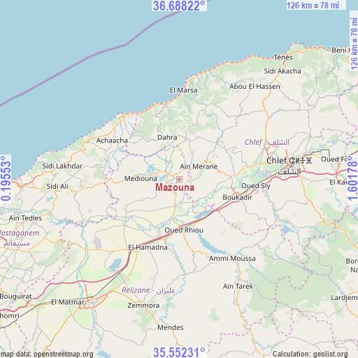
Mazouna GPS coordinates[2]
36° 7' 20.352" North, 0° 53' 55.14" East
| Map corner | latitude | longitude |
|---|---|---|
| Upper-left | 36.68822°, | 0.19553° |
| Center: | 36.12232°, | 0.89865° |
| Lower-right: | 35.55231°, | 1.60178° |
| Map W x H: | 126.3×126.3 km | = 78.5×78.5mi |
| max Lat: | 36.92917° ⇑48.1% North |
| Mazouna: | 36.12232° |
| min Lat: | ⇓51.9% South 22.785° |
| min Long | Mazouna | max Long |
| -8.14743° | 0.89865° | 8.46667° |
| W 19%⇐ | ⇒81% E |
Elevation
Elevation of Mazouna is 342 m = 1122 ft, and this is 96.5 m = 317 ft below average elevation for this country.
| Max E: |
1392 m = 4567 ft | 47.3% |
| Avg. | 438.5 m = 1439 ft | |
| Mazouna | 342 m = 1122 ft | |
Min E: |
5 m = 16 ft | 52.7% |
See also: Algeria elevation on elevation.city.
Geographical zone
Mazouna is located in North temperate zone (between Tropic of Cancer and the Arctic Circle). Distance of this Northern Tropic circle is 1410.5 km =876.4 mi to South.| Distance of | km | miles | from Mazouna |
|---|---|---|---|
| North Pole | 5990.6 | 3722.4 | to North |
| Arctic Circle | 3384.7 | 2103.2 | to North |
| Tropic Cancer | 1410.5 | 876.4 | to South |
| Equator | 4016.4 | 2495.7 | to South |


Nearby cities:
15 places around Mazouna: (largest is in red/bold)
• Abou el Hassan
42.2 km =26.2 mi,  39°
39°
• Ammi Moussa
34.2 km =21.3 mi,  145°
145°
• Boukadir
21.4 km =13.3 mi,  106°
106°
• Chlef
39.4 km =24.5 mi,  83°
83°
• Djidiouia
22.3 km =13.9 mi,  196°
196°
• Ech Chettia
33.1 km =20.6 mi, 75°
• Oued Fodda
57.4 km =35.7 mi, 83°
• Oued Rhiou
18 km =11.2 mi,  174°
174°
• Oued Sly
27.1 km =16.8 mi,  94°
94°
• Relizane
52.8 km =32.8 mi,  215°
215°
• Rouachdia
48.4 km =30.1 mi, 198°
• Sidi Akkacha
52.5 km =32.6 mi, 43°
• Smala
47 km =29.2 mi, 196°
• Zemoura
46.3 km =28.8 mi, 196°
• ’Aïn Merane
7.9 km =4.9 mi,  55°
55°
Sources, notices
• [Note1] Compared only with cities in Algeria existing in our database
• [Src1] Map data: © OpenStreetMap contributors (CC-BY-SA)
• [Src2] Other city data from geonames.org with taken over terms of usage.
• [Src3] Geographical zone / Annual Mean Temperature by Robert A. Rohde @ Wikipedia
