Balzar geodata
Balzar (Guayas) is a populated place; located in Ecuador in America/Guayaquil (GMT-5) time zone. With population of 40,115 people, there are 29 cities with bigger population in this country. Compared to other cities in Ecuador, 53.7% of cities are located further ↓South; 71.9% of cities are located further →East and 65.3% of cities have higher elevation than Balzar. Note1


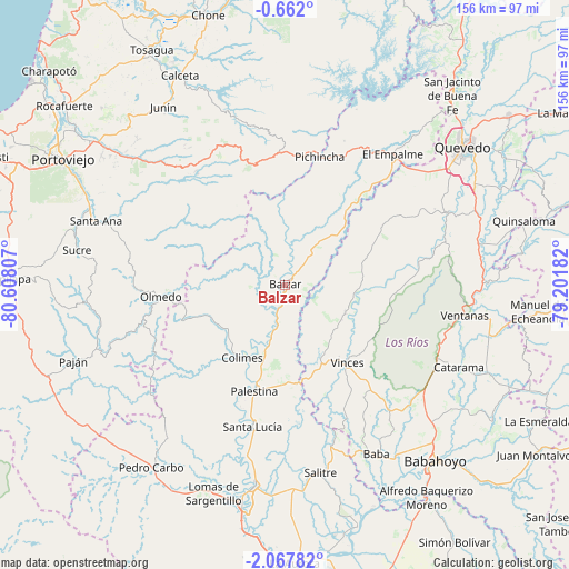
Balzar GPS coordinates[2]
1° 21' 54.036" South, 79° 54' 17.784" West
| Map corner | latitude | longitude |
|---|---|---|
| Upper-left | -0.662°, | -80.60807° |
| Center: | -1.36501°, | -79.90494° |
| Lower-right: | -2.06782°, | -79.20182° |
| Map W x H: | 156.3×156.3 km | = 97.1×97.1mi |
| max Lat: | 1.35251° ⇑46.3% North |
| Balzar: | -1.36501° |
| min Lat: | ⇓53.7% South -4.38181° |
| min Long | Balzar | max Long |
| -90.96654° | -79.90494° | -76.89528° |
| W 28.1%⇐ | ⇒71.9% E |
Elevation
Elevation of Balzar is 41 m = 135 ft, and this is 904.1 m = 2966 ft below average elevation for this country.
| Max E: |
3131 m = 10272 ft | 65.3% |
| Avg. | 945.1 m = 3101 ft | |
| Balzar | 41 m = 135 ft | |
Min E: |
1 m = 3 ft | 34.7% |
See also: Balzar elevation on elevation.city.
Geographical zone
Balzar is located in South Torrid zone (between Equator and Tropic of Capricorn). Distance of Equator is 151.8 km =94.3 mi to North.| Distance of | km | miles | from Balzar |
|---|---|---|---|
| Equator | 151.8 | 94.3 | to North |
| Tropic Capricorn | 2454.1 | 1524.9 | to South |
| Antarctic Circle | 7249.4 | 4504.6 | to South |
| South Pole | 9855.3 | 6123.8 | to South |


Nearby cities:
15 places around Balzar: (largest is in red/bold)
• Babahoyo
63.7 km =39.6 mi,  139°
139°
• Catarama
54.7 km =34 mi,  115°
115°
• Colimes
23.3 km =14.5 mi,  210°
210°
• El Triunfo
63.6 km =39.5 mi,  186°
186°
• Junín
59 km =36.7 mi,  325°
325°
• Lomas de Sargentillo
60.9 km =37.8 mi,  198°
198°
• Paján
61.9 km =38.5 mi,  250°
250°
• Palenque
18.4 km =11.4 mi, 116°
• Pedro Carbo
62 km =38.5 mi,  216°
216°
• Quevedo
61.7 km =38.3 mi,  52°
52°
• Santa Ana
54.7 km =34 mi,  288°
288°
• Sucre
57.9 km =36 mi,  279°
279°
• Velasco Ibarra
46.4 km =28.8 mi,  39°
39°
• Ventanas
50.2 km =31.2 mi,  99°
99°
• Vinces
27.2 km =16.9 mi, 141°
Sources, notices
• [Note1] Compared only with cities in Ecuador existing in our database
• [Src1] Map data: © OpenStreetMap contributors (CC-BY-SA)
• [Src2] Other city data from geonames.org with taken over terms of usage.
• [Src3] Geographical zone / Annual Mean Temperature by Robert A. Rohde @ Wikipedia
