Palenque geodata
Palenque (Los Ríos) is a populated place; located in Ecuador in America/Guayaquil (GMT-5) time zone. With population of 9,083 people, there are 91 cities with bigger population in this country. Compared to other cities in Ecuador, 51.2% of cities are located further ↓South; 67.8% of cities are located further →East and 66.9% of cities have higher elevation than Palenque. Note1


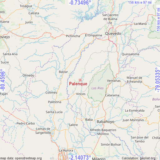
Palenque GPS coordinates[2]
1° 26' 16.62" South, 79° 45' 23.292" West
| Map corner | latitude | longitude |
|---|---|---|
| Upper-left | -0.73496°, | -80.4596° |
| Center: | -1.43795°, | -79.75647° |
| Lower-right: | -2.14073°, | -79.05335° |
| Map W x H: | 156.3×156.3 km | = 97.1×97.1mi |
| max Lat: | 1.35251° ⇑48.8% North |
| Palenque: | -1.43795° |
| min Lat: | ⇓51.2% South -4.38181° |
| min Long | Palenque | max Long |
| -90.96654° | -79.75647° | -76.89528° |
| W 32.2%⇐ | ⇒67.8% E |
Elevation
Elevation of Palenque is 31 m = 102 ft, and this is 914.1 m = 2999 ft below average elevation for this country.
| Max E: |
3131 m = 10272 ft | 66.9% |
| Avg. | 945.1 m = 3101 ft | |
| Palenque | 31 m = 102 ft | |
Min E: |
1 m = 3 ft | 33.1% |
See also: Ecuador elevation on elevation.city.
Geographical zone
Palenque is located in South Torrid zone (between Equator and Tropic of Capricorn). Distance of Equator is 159.9 km =99.4 mi to North.| Distance of | km | miles | from Palenque |
|---|---|---|---|
| Equator | 159.9 | 99.4 | to North |
| Tropic Capricorn | 2446 | 1519.9 | to South |
| Antarctic Circle | 7241.3 | 4499.5 | to South |
| South Pole | 9847.2 | 6118.8 | to South |


Nearby cities:
15 places around Palenque: (largest is in red/bold)
• Alfredo Baquerizo Moreno
59.5 km =37 mi,  153°
153°
• Babahoyo
47.4 km =29.5 mi, 148°
• Balzar
18.4 km =11.4 mi,  296°
296°
• Catarama
36.3 km =22.6 mi,  114°
114°
• Colimes
30.8 km =19.1 mi,  247°
247°
• El Triunfo
59.8 km =37.2 mi,  202°
202°
• Lomas de Sargentillo
61.4 km =38.2 mi,  216°
216°
• Montalvo
65.2 km =40.5 mi,  126°
126°
• Palestina
55.7 km =34.6 mi,  175°
175°
• Pedro Carbo
67.6 km =42 mi,  231°
231°
• Quevedo
56 km =34.8 mi,  35°
35°
• Samborondón
58.5 km =36.4 mi, 176°
• Velasco Ibarra
45.8 km =28.5 mi,  16°
16°
• Ventanas
33 km =20.5 mi,  90°
90°
• Vinces
13.1 km =8.1 mi, 177°
Sources, notices
• [Note1] Compared only with cities in Ecuador existing in our database
• [Src1] Map data: © OpenStreetMap contributors (CC-BY-SA)
• [Src2] Other city data from geonames.org with taken over terms of usage.
• [Src3] Geographical zone / Annual Mean Temperature by Robert A. Rohde @ Wikipedia
