Aravete geodata
Aravete (Järvamaa) is a populated place; located in Estonia in Europe/Tallinn (GMT+3) time zone. With population of 955 people, there are 97 cities with bigger population in this country. Compared to other cities in Estonia, 63.2% of cities are located further ↓South; 56.8% of cities are located further ←West and 93.2% of cities have lower elevation than Aravete. Note1


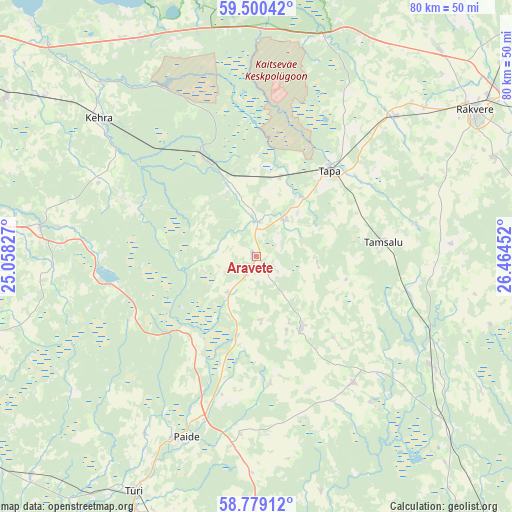
Aravete GPS coordinates[2]
59° 8' 30.012" North, 25° 45' 41.004" East
| Map corner | latitude | longitude |
|---|---|---|
| Upper-left | 59.50042°, | 25.05827° |
| Center: | 59.14167°, | 25.76139° |
| Lower-right: | 58.77912°, | 26.46452° |
| Map W x H: | 80.2×80.2 km | = 49.8×49.8mi |
| max Lat: | 59.57639° ⇑36.8% North |
| Aravete: | 59.14167° |
| min Lat: | ⇓63.2% South 57.72778° |
| min Long | Aravete | max Long |
| 22.24646° | 25.76139° | 28.19028° |
| W 56.8%⇐ | ⇒43.2% E |
Elevation
Elevation of Aravete is 98 m = 322 ft, and this is 44.8 m = 147 ft above average elevation for this country.
| Max E: |
141 m = 463 ft | 6.8% |
| Aravete | 98 m 322 ft | |
| Avg. | 53.2 m = 175 ft | |
Min E: |
6 m = 20 ft | 93.2% |
See also: Estonia elevation on elevation.city.
Geographical zone
Aravete is located in North temperate zone (between Tropic of Cancer and the Arctic Circle). Distance of this North polar circle is 825.2 km =512.8 mi to North.| Distance of | km | miles | from Aravete |
|---|---|---|---|
| North Pole | 3431.1 | 2132 | to North |
| Arctic Circle | 825.2 | 512.8 | to North |
| Tropic Cancer | 3970 | 2466.8 | to South |
| Equator | 6575.9 | 4086.1 | to South |


Nearby cities:
15 places around Aravete: (largest is in red/bold)
• Aegviidu
18.1 km =11.2 mi,  332°
332°
• Ardu
22.8 km =14.2 mi,  258°
258°
• Järva-Jaani
13.5 km =8.4 mi,  148°
148°
• Kadrina
30.6 km =19 mi,  45°
45°
• Kehra
33.1 km =20.6 mi,  310°
310°
• Koeru
25.1 km =15.6 mi,  142°
142°
• Kose
33.8 km =21 mi,  277°
277°
• Lehtmetsa
30.4 km =18.9 mi, 310°
• Paide
30.8 km =19.1 mi,  202°
202°
• Rakke
33.3 km =20.7 mi,  122°
122°
• Tamsalu
20.3 km =12.6 mi,  84°
84°
• Tapa
17.3 km =10.7 mi,  40°
40°
• Vaiatu
27.2 km =16.9 mi,  29°
29°
• Vyatsa
33.7 km =20.9 mi,  212°
212°
• Väike-Maarja
27.9 km =17.3 mi,  93°
93°
Sources, notices
• [Note1] Compared only with cities in Estonia existing in our database
• [Src1] Map data: © OpenStreetMap contributors (CC-BY-SA)
• [Src2] Other city data from geonames.org with taken over terms of usage.
• [Src3] Geographical zone / Annual Mean Temperature by Robert A. Rohde @ Wikipedia
