Kafr Şaqr geodata
Kafr Şaqr (Sharqia) is a populated place; located in Egypt in Africa/Cairo (GMT+2) time zone. With population of 34,967 people, there are 112 cities with bigger population in this country. Compared to other cities in Egypt, 71% of cities are located further ↓South; 65.2% of cities are located further ←West and 81.2% of cities have higher elevation than Kafr Şaqr. Note1


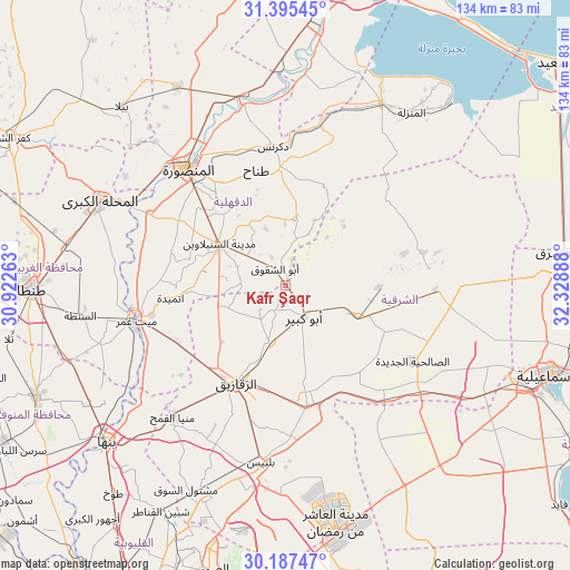
Kafr Şaqr GPS coordinates[2]
30° 47' 36.096" North, 31° 37' 32.7" East
| Map corner | latitude | longitude |
|---|---|---|
| Upper-left | 31.39545°, | 30.92263° |
| Center: | 30.79336°, | 31.62575° |
| Lower-right: | 30.18747°, | 32.32888° |
| Map W x H: | 134.3×134.3 km | = 83.5×83.5mi |
| max Lat: | 31.5084° ⇑29% North |
| Kafr Şaqr: | 30.79336° |
| min Lat: | ⇓71% South 22.3457° |
| min Long | Kafr Şaqr | max Long |
| 25.51965° | 31.62575° | 34.89572° |
| W 65.2%⇐ | ⇒34.8% E |
Elevation
Elevation of Kafr Şaqr is 11 m = 36 ft, and this is 32.5 m = 107 ft below average elevation for this country.
| Max E: |
1565 m = 5135 ft | 81.2% |
| Avg. | 43.5 m = 143 ft | |
| Kafr Şaqr | 11 m = 36 ft | |
Min E: |
-15 m = -49 ft | 18.8% |
See also: Egypt elevation on elevation.city.
Geographical zone
Kafr Şaqr is located in North temperate zone (between Tropic of Cancer and the Arctic Circle). Distance of this Northern Tropic circle is 818 km =508.3 mi to South.| Distance of | km | miles | from Kafr Şaqr |
|---|---|---|---|
| North Pole | 6583.2 | 4090.6 | to North |
| Arctic Circle | 3977.3 | 2471.4 | to North |
| Tropic Cancer | 818 | 508.3 | to South |
| Equator | 3423.9 | 2127.5 | to South |


Nearby cities:
15 places around Kafr Şaqr: (largest is in red/bold)
• Abū Kabīr
8.8 km =5.5 mi,  150°
150°
• Ajā
36 km =22.4 mi,  297°
297°
• Al Ibrāhīmīyah
10.2 km =6.3 mi,  215°
215°
• Al Manşūrah
35.7 km =22.2 mi,  319°
319°
• Al Qanāyāt
24.9 km =15.5 mi, 219°
• Al Qurayn
22.3 km =13.9 mi, 152°
• At Tall al Kabīr
31.7 km =19.7 mi, 151°
• Dikirnis
33 km =20.5 mi,  354°
354°
• Diyarb Najm
18.3 km =11.4 mi,  256°
256°
• Fāqūs
17.9 km =11.1 mi,  113°
113°
• Hihyā
14 km =8.7 mi,  194°
194°
• Minyat an Naşr
37 km =23 mi,  2°
2°
• Zagazig
25.7 km =16 mi,  207°
207°
• Zefta
37.5 km =23.3 mi, 256°
• Ţalkhā
37.4 km =23.2 mi, 320°
Sources, notices
• [Note1] Compared only with cities in Egypt existing in our database
• [Src1] Map data: © OpenStreetMap contributors (CC-BY-SA)
• [Src2] Other city data from geonames.org with taken over terms of usage.
• [Src3] Geographical zone / Annual Mean Temperature by Robert A. Rohde @ Wikipedia
