Al Manşūrah geodata
Al Manşūrah (Dakahlia) is a seat of a first-order administrative division; located in Egypt in Africa/Cairo (GMT+2) time zone. With population of 420,195 people, there are 8 cities with bigger population in this country. Compared to other cities in Egypt, 80.4% of cities are located further ↓South; 55.1% of cities are located further ←West and 61.6% of cities have higher elevation than Al Manşūrah. Note1


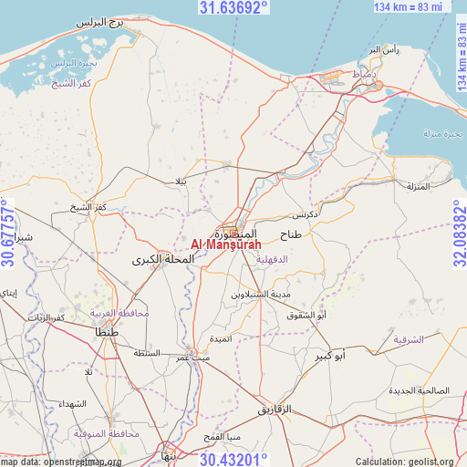
Al Manşūrah GPS coordinates[2]
31° 2' 10.932" North, 31° 22' 50.484" East
| Map corner | latitude | longitude |
|---|---|---|
| Upper-left | 31.63692°, | 30.67757° |
| Center: | 31.03637°, | 31.38069° |
| Lower-right: | 30.43201°, | 32.08382° |
| Map W x H: | 134×134 km | = 83.3×83.3mi |
| max Lat: | 31.5084° ⇑19.6% North |
| Al Manşūrah: | 31.03637° |
| min Lat: | ⇓80.4% South 22.3457° |
| min Long | Al Manşūrah | max Long |
| 25.51965° | 31.38069° | 34.89572° |
| W 55.1%⇐ | ⇒44.9% E |
Elevation
Elevation of Al Manşūrah is 15 m = 49 ft, and this is 28.5 m = 94 ft below average elevation for this country.
| Max E: |
1565 m = 5135 ft | 61.6% |
| Avg. | 43.5 m = 143 ft | |
| Al Manşūrah | 15 m = 49 ft | |
Min E: |
-15 m = -49 ft | 38.4% |
See also: Al Manşūrah elevation on elevation.city.
Geographical zone
Al Manşūrah is located in North temperate zone (between Tropic of Cancer and the Arctic Circle). Distance of this Northern Tropic circle is 845 km =525.1 mi to South.| Distance of | km | miles | from Al Manşūrah |
|---|---|---|---|
| North Pole | 6556.1 | 4073.8 | to North |
| Arctic Circle | 3950.3 | 2454.6 | to North |
| Tropic Cancer | 845 | 525.1 | to South |
| Equator | 3450.9 | 2144.3 | to South |


Nearby cities:
15 places around Al Manşūrah: (largest is in red/bold)
• Ajā
13.6 km =8.5 mi,  219°
219°
• Al Ibrāhīmīyah
39.4 km =24.5 mi,  153°
153°
• Al Maḩallah al Kubrá
21.6 km =13.4 mi,  250°
250°
• Al Ḩāmūl
37.8 km =23.5 mi,  324°
324°
• Az Zarqā
30.9 km =19.2 mi,  51°
51°
• Bilqās
19.9 km =12.4 mi,  353°
353°
• Dikirnis
21.2 km =13.2 mi,  73°
73°
• Diyarb Najm
31.9 km =19.8 mi,  169°
169°
• Kafr Şaqr
35.7 km =22.2 mi,  139°
139°
• Minyat an Naşr
26.9 km =16.7 mi, 68°
• Quţūr
41.1 km =25.5 mi,  260°
260°
• Samannūd
15.7 km =9.8 mi,  238°
238°
• Shirbīn
22.5 km =14 mi,  37°
37°
• Zefta
38.1 km =23.7 mi,  199°
199°
• Ţalkhā
2 km =1.2 mi, 352°
Sources, notices
• [Note1] Compared only with cities in Egypt existing in our database
• [Src1] Map data: © OpenStreetMap contributors (CC-BY-SA)
• [Src2] Other city data from geonames.org with taken over terms of usage.
• [Src3] Geographical zone / Annual Mean Temperature by Robert A. Rohde @ Wikipedia
