Ţalkhā geodata
Ţalkhā (Dakahlia) is a populated place; located in Egypt in Africa/Cairo (GMT+2) time zone. With population of 157,737 people, there are 25 cities with bigger population in this country. Compared to other cities in Egypt, 81.2% of cities are located further ↓South; 54.3% of cities are located further ←West and 90.6% of cities have higher elevation than Ţalkhā. Note1


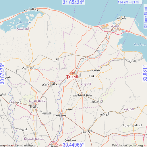
Ţalkhā GPS coordinates[2]
31° 3' 14.04" North, 31° 22' 40.332" East
| Map corner | latitude | longitude |
|---|---|---|
| Upper-left | 31.65434°, | 30.67475° |
| Center: | 31.0539°, | 31.37787° |
| Lower-right: | 30.44965°, | 32.081° |
| Map W x H: | 133.9×134 km | = 83.2×83.3mi |
| max Lat: | 31.5084° ⇑18.8% North |
| Ţalkhā: | 31.0539° |
| min Lat: | ⇓81.2% South 22.3457° |
| min Long | Ţalkhā | max Long |
| 25.51965° | 31.37787° | 34.89572° |
| W 54.3%⇐ | ⇒45.7% E |
Elevation
Elevation of Ţalkhā is 7 m = 23 ft, and this is 36.5 m = 120 ft below average elevation for this country.
| Max E: |
1565 m = 5135 ft | 90.6% |
| Avg. | 43.5 m = 143 ft | |
| Ţalkhā | 7 m = 23 ft | |
Min E: |
-15 m = -49 ft | 9.4% |
See also: Ţalkhā elevation on elevation.city.
Geographical zone
Ţalkhā is located in North temperate zone (between Tropic of Cancer and the Arctic Circle). Distance of this Northern Tropic circle is 847 km =526.3 mi to South.| Distance of | km | miles | from Ţalkhā |
|---|---|---|---|
| North Pole | 6554.2 | 4072.6 | to North |
| Arctic Circle | 3948.3 | 2453.4 | to North |
| Tropic Cancer | 847 | 526.3 | to South |
| Equator | 3452.9 | 2145.5 | to South |


Nearby cities:
15 places around Ţalkhā: (largest is in red/bold)
• Ajā
15 km =9.3 mi,  213°
213°
• Al Ibrāhīmīyah
41.2 km =25.6 mi,  154°
154°
• Al Manşūrah
2 km =1.2 mi,  172°
172°
• Al Maḩallah al Kubrá
22.1 km =13.7 mi,  245°
245°
• Al Ḩāmūl
36.1 km =22.4 mi,  322°
322°
• Az Zarqā
29.9 km =18.6 mi,  54°
54°
• Bilqās
18 km =11.2 mi,  353°
353°
• Dikirnis
21 km =13 mi,  79°
79°
• Diyarb Najm
33.8 km =21 mi, 169°
• Kafr Şaqr
37.4 km =23.2 mi,  140°
140°
• Minyat an Naşr
26.5 km =16.5 mi,  72°
72°
• Quţūr
41.2 km =25.6 mi,  257°
257°
• Samannūd
16.6 km =10.3 mi,  231°
231°
• Shirbīn
21.1 km =13.1 mi,  41°
41°
• Zefta
39.9 km =24.8 mi,  198°
198°
Sources, notices
• [Note1] Compared only with cities in Egypt existing in our database
• [Src1] Map data: © OpenStreetMap contributors (CC-BY-SA)
• [Src2] Other city data from geonames.org with taken over terms of usage.
• [Src3] Geographical zone / Annual Mean Temperature by Robert A. Rohde @ Wikipedia
