Idkū geodata
Idkū (Beheira) is a seat of a second-order administrative division; located in Egypt in Africa/Cairo (GMT+2) time zone. With population of 210,678 people, there are 19 cities with bigger population in this country. Compared to other cities in Egypt, 95.7% of cities are located further ↓South; 93.5% of cities are located further →East and 88.4% of cities have higher elevation than Idkū. Note1


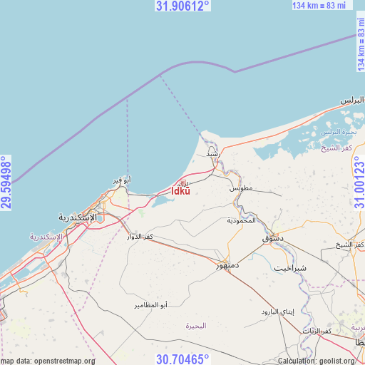
Idkū GPS coordinates[2]
31° 18' 26.28" North, 30° 17' 53.16" East
| Map corner | latitude | longitude |
|---|---|---|
| Upper-left | 31.90612°, | 29.59498° |
| Center: | 31.3073°, | 30.2981° |
| Lower-right: | 30.70465°, | 31.00123° |
| Map W x H: | 133.6×133.6 km | = 83×83mi |
| max Lat: | 31.5084° ⇑4.3% North |
| Idkū: | 31.3073° |
| min Lat: | ⇓95.7% South 22.3457° |
| min Long | Idkū | max Long |
| 25.51965° | 30.2981° | 34.89572° |
| W 6.5%⇐ | ⇒93.5% E |
Elevation
Elevation of Idkū is 8 m = 26 ft, and this is 35.5 m = 116 ft below average elevation for this country.
| Max E: |
1565 m = 5135 ft | 88.4% |
| Avg. | 43.5 m = 143 ft | |
| Idkū | 8 m = 26 ft | |
Min E: |
-15 m = -49 ft | 11.6% |
See also: Idkū elevation on elevation.city.
Geographical zone
Idkū is located in North temperate zone (between Tropic of Cancer and the Arctic Circle). Distance of this Northern Tropic circle is 875.1 km =543.8 mi to South.| Distance of | km | miles | from Idkū |
|---|---|---|---|
| North Pole | 6526 | 4055.1 | to North |
| Arctic Circle | 3920.1 | 2435.8 | to North |
| Tropic Cancer | 875.1 | 543.8 | to South |
| Equator | 3481 | 2163 | to South |


Nearby cities:
15 places around Idkū: (largest is in red/bold)
• Abū al Maţāmīr
45.7 km =28.4 mi,  194°
194°
• Ad Dilinjāt
57.9 km =36 mi,  157°
157°
• Alexandria
38.2 km =23.7 mi,  252°
252°
• Basyūn
63.8 km =39.6 mi,  129°
129°
• Damanhūr
34.4 km =21.4 mi,  151°
151°
• Disūq
38.5 km =23.9 mi,  120°
120°
• Fuwwah
26.5 km =16.5 mi, 115°
• Kafr ad Dawwār
25.1 km =15.6 mi,  219°
219°
• Kafr ash Shaykh
64.8 km =40.3 mi,  109°
109°
• Kawm Ḩamādah
71.8 km =44.6 mi, 147°
• Munshāt ‘Alī Āghā
41.8 km =26 mi, 113°
• Quţūr
72.9 km =45.3 mi, 120°
• Rosetta
15.3 km =9.5 mi,  47°
47°
• Sīdī Sālim
46.5 km =28.9 mi,  94°
94°
• Ḩawsh ‘Īsá
43.9 km =27.3 mi,  180°
180°
Sources, notices
• [Note1] Compared only with cities in Egypt existing in our database
• [Src1] Map data: © OpenStreetMap contributors (CC-BY-SA)
• [Src2] Other city data from geonames.org with taken over terms of usage.
• [Src3] Geographical zone / Annual Mean Temperature by Robert A. Rohde @ Wikipedia
