Quţūr geodata
Quţūr (Gharbia) is a populated place; located in Egypt in Africa/Cairo (GMT+2) time zone. With population of 23,842 people, there are 119 cities with bigger population in this country. Compared to other cities in Egypt, 78.3% of cities are located further ↓South; 71% of cities are located further →East and 86.2% of cities have higher elevation than Quţūr. Note1


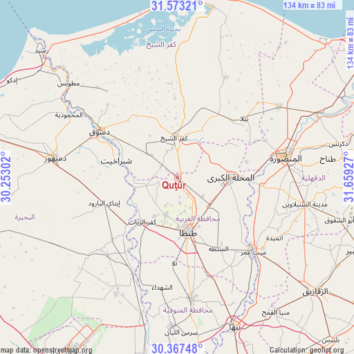
Quţūr GPS coordinates[2]
30° 58' 20.1" North, 30° 57' 22.104" East
| Map corner | latitude | longitude |
|---|---|---|
| Upper-left | 31.57321°, | 30.25302° |
| Center: | 30.97225°, | 30.95614° |
| Lower-right: | 30.36748°, | 31.65927° |
| Map W x H: | 134.1×134.1 km | = 83.3×83.3mi |
| max Lat: | 31.5084° ⇑21.7% North |
| Quţūr: | 30.97225° |
| min Lat: | ⇓78.3% South 22.3457° |
| min Long | Quţūr | max Long |
| 25.51965° | 30.95614° | 34.89572° |
| W 29%⇐ | ⇒71% E |
Elevation
Elevation of Quţūr is 9 m = 30 ft, and this is 34.5 m = 113 ft below average elevation for this country.
| Max E: |
1565 m = 5135 ft | 86.2% |
| Avg. | 43.5 m = 143 ft | |
| Quţūr | 9 m = 30 ft | |
Min E: |
-15 m = -49 ft | 13.8% |
See also: Egypt elevation on elevation.city.
Geographical zone
Quţūr is located in North temperate zone (between Tropic of Cancer and the Arctic Circle). Distance of this Northern Tropic circle is 837.9 km =520.6 mi to South.| Distance of | km | miles | from Quţūr |
|---|---|---|---|
| North Pole | 6563.3 | 4078.2 | to North |
| Arctic Circle | 3957.4 | 2459 | to North |
| Tropic Cancer | 837.9 | 520.6 | to South |
| Equator | 3443.8 | 2139.9 | to South |


Nearby cities:
15 places around Quţūr: (largest is in red/bold)
• Ajā
32.1 km =19.9 mi,  96°
96°
• Al Manşūrah
41.1 km =25.5 mi,  80°
80°
• Al Maḩallah al Kubrá
20.1 km =12.5 mi,  90°
90°
• Basyūn
14.1 km =8.8 mi,  255°
255°
• Disūq
34.4 km =21.4 mi,  301°
301°
• Kafr ash Shaykh
15.6 km =9.7 mi,  354°
354°
• Kafr az Zayyāt
21 km =13 mi,  218°
218°
• Kawm Ḩamādah
33.9 km =21.1 mi,  226°
226°
• Munshāt ‘Alī Āghā
31.8 km =19.8 mi,  310°
310°
• Samannūd
27.2 km =16.9 mi, 92°
• Sīdī Sālim
37 km =23 mi,  334°
334°
• Talā
32.5 km =20.2 mi,  182°
182°
• Tanda
20.9 km =13 mi,  167°
167°
• Zefta
39.7 km =24.7 mi,  136°
136°
• Ţalkhā
41.2 km =25.6 mi, 77°
Sources, notices
• [Note1] Compared only with cities in Egypt existing in our database
• [Src1] Map data: © OpenStreetMap contributors (CC-BY-SA)
• [Src2] Other city data from geonames.org with taken over terms of usage.
• [Src3] Geographical zone / Annual Mean Temperature by Robert A. Rohde @ Wikipedia
