Zafra geodata
Zafra (Extremadura) is a seat of a third-order administrative division; located in Spain in Europe/Madrid (GMT+2) time zone. With population of 16,424 people, there are 573 cities with bigger population in this country. Compared to other cities in Spain, 86% of cities are located further ↑North; 90.6% of cities are located further →East and 60.8% of cities have higher elevation than Zafra. Note1


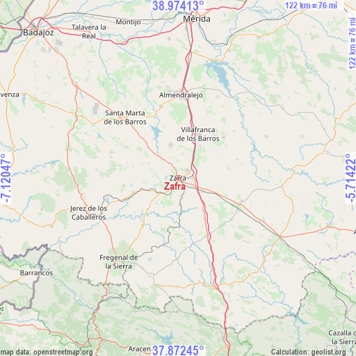
Zafra GPS coordinates[2]
38° 25' 31.404" North, 6° 25' 2.424" West
| Map corner | latitude | longitude |
|---|---|---|
| Upper-left | 38.97413°, | -7.12047° |
| Center: | 38.42539°, | -6.41734° |
| Lower-right: | 37.87245°, | -5.71422° |
| Map W x H: | 122.5×122.5 km | = 76.1×76.1mi |
| max Lat: | 43.74134° ⇑86% North |
| Zafra: | 38.42539° |
| min Lat: | ⇓14% South 27.64134° |
| min Long | Zafra | max Long |
| -18.00367° | -6.41734° | 4.2899° |
| W 9.4%⇐ | ⇒90.6% E |
Elevation
Elevation of Zafra is 517 m = 1696 ft, and this is 81 m = 266 ft below average elevation for this country.
| Max E: |
1682 m = 5518 ft | 60.8% |
| Avg. | 598 m = 1962 ft | |
| Zafra | 517 m = 1696 ft | |
Min E: |
0 m = 0 ft | 39.2% |
See also: Spain elevation on elevation.city.
Geographical zone
Zafra is located in North temperate zone (between Tropic of Cancer and the Arctic Circle). Distance of this Northern Tropic circle is 1666.6 km =1035.6 mi to South.| Distance of | km | miles | from Zafra |
|---|---|---|---|
| North Pole | 5734.6 | 3563.3 | to North |
| Arctic Circle | 3128.7 | 1944.1 | to North |
| Tropic Cancer | 1666.6 | 1035.6 | to South |
| Equator | 4272.5 | 2654.8 | to South |


Nearby cities:
15 places around Zafra: (largest is in red/bold)
• Alconera
5.1 km =3.2 mi,  236°
236°
• Atalaya
11.1 km =6.9 mi,  202°
202°
• Burguillos del Cerro
15.9 km =9.9 mi,  251°
251°
• Calzadilla de Los Barros
16.5 km =10.3 mi,  147°
147°
• Feria
16 km =9.9 mi,  306°
306°
• Fuente del Maestre
11.6 km =7.2 mi,  346°
346°
• Hinojosa del Valle
21.4 km =13.3 mi,  72°
72°
• La Parra
20.8 km =12.9 mi,  300°
300°
• Los Santos de Maimona
4 km =2.5 mi,  47°
47°
• Medina de las Torres
10.3 km =6.4 mi,  171°
171°
• Puebla de Sancho Pérez
3.2 km =2 mi, 151°
• Ribera del Fresno
21 km =13 mi, 48°
• Valencia del Ventoso
18.2 km =11.3 mi,  193°
193°
• Valverde de Burguillos
15.1 km =9.4 mi,  223°
223°
• Villafranca de los Barros
16.6 km =10.3 mi,  24°
24°
Sources, notices
• [Note1] Compared only with cities in Spain existing in our database
• [Src1] Map data: © OpenStreetMap contributors (CC-BY-SA)
• [Src2] Other city data from geonames.org with taken over terms of usage.
• [Src3] Geographical zone / Annual Mean Temperature by Robert A. Rohde @ Wikipedia
